ponts couverts dans le monde
bedeckte Brücken der Welt
世界各地的棚桥

45-13 Windham county/comté/grafschaft/温德姆县
13 covered bridges/ponts couverts/bedeckte
Brücken/十三廊桥
![]()
This symbol indicates this listing has been translated from
English to French and German by ATAWALK
Ce symbole indique que la traduction de cette liste fut effectuer à partir
de l'anglais au Français et à l'Allemand par ATAWALK
Dieses Symbol deutet darauf hin, dass diese Auflistung von ATAWALK vom Englischen
ins Französische und Deutsche übersetzt wurde.
此符号表示此物品已被翻译从英语到法语,德语和ATAWALK中 .
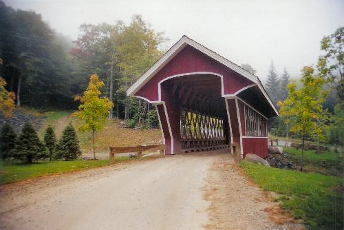
BRATTLEBOROUGH
| 45-13-01 |
At the western edge of Brattleborough off VT 9 À la limite ouest de Brattleborough près de la VT9 An der westlichen Begrenzung auf Brattleborough neben VT 9 |
Whetstone Brook Ruisseau Whetstone Whetstone Bach |
Creamery Bridge Pont de la Crèmerie Molkerei Brücke |
0.4 mile west of jct I-91 at exit 2 on VT 9 then just left at Guilford Street to the bridge 0.4 mile à l'ouest de la I-91 sortie No 2 sur la VT9 et à gauche sur la rue Guilford 0,4 Meile westlich von jct I-91 am Ausfahrt 2 auf VT 9 dann linke auf Straße Guilford zur die Brücke |
1 | 84' 25.6m |
Built in 1879, sidewalk added in 1917 Construit en 1879, trottoir ajouter en 1917 Errichtet 1879, ein Bürgersteig wurde im Jahre 1917 gebaut |
Town lattice Treillis Town Town Träger |
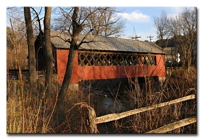
The Creamery bridge at Brattleboro, photo by Alan B. Hartmann
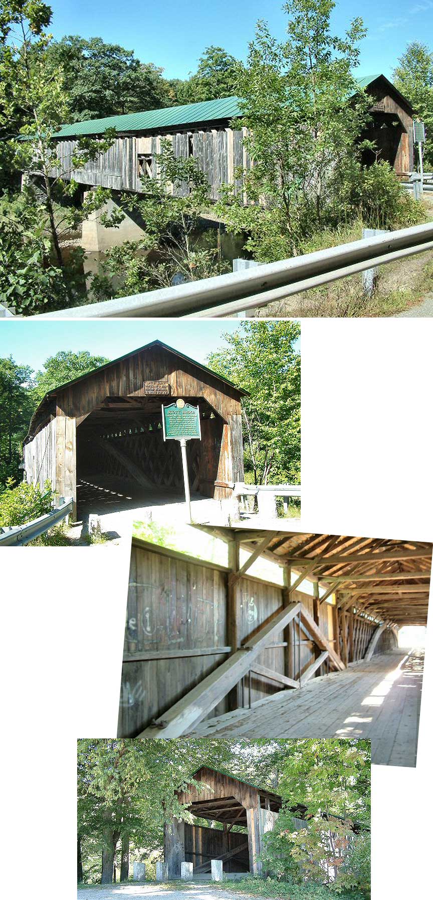
DUMMERSTON
| 45-13-02 |
North of West-Dummerston off VT30 Au nord de Dummerston-Ouest près de la VT30 Norden von West-Dummerston ne |
West River Rivière de l'ouest West Fluß |
West-Dummerston Bridge, the longest covered bridge in Vermont Pont couvert de Dummerston-Ouest, le plus grand au Vermont Westen-Dummerstonbrücke, die längste bedeckte Brücke in Vermont |
7 miles NW of jct US 5 north of Brattleboro on VT 30 just past West-Dummerston then just right at the bridge 7 miles au nord ouest de la US5 au nord de Brattleboro sur la passer Dummerston-Ouest sur la VT30 et à droite au pont 7 Meilen im Westnorden des US5 im Norden von Brattleboro bis zum Dummerston-Westen auf dem VT30 und rechts zur die Brücke |
2 | 280' 85.3m |
Built in 1872 by Caleb B. Lamson, completely restored in 1998 Construit en 1872 par Caleb B. Lamson, complètement Errichtet 1872 durch Caleb B. Lamson, vollständig wieder hergestellt 1998 |
Town lattice Treillis Town Town Träger |
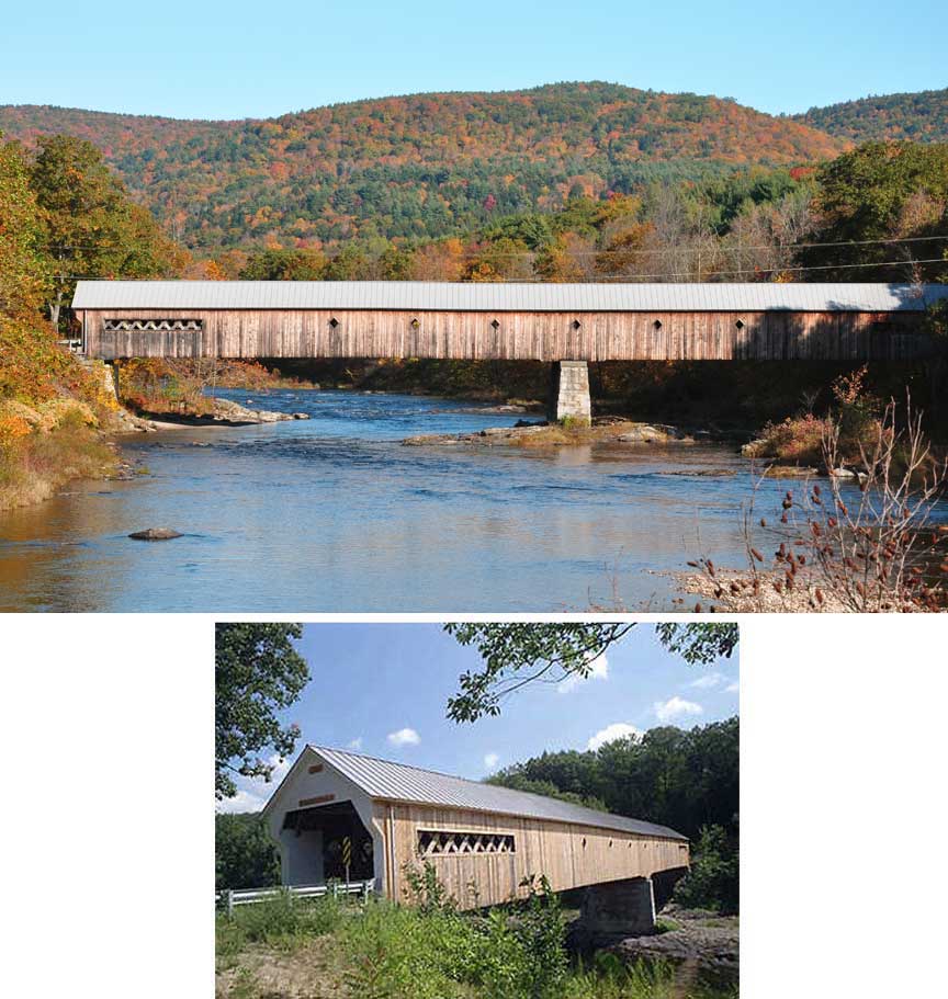
The West-Dummerston Bridge, the longest in Vermont proper, photos by Scott Wagner & Dave MacKenzie of VirtualVermont
GRAFTON
| 45-13-03 |
South edge of Grafton on Bear Hill Road À la limite sud de Grafton sur le chemin Côte-à-l'our (Bear Hill) Südrand von Grafton auf Bärenhügelstraße |
South Branch of the Saxton River Branche sud de la rivière Saxton Südniederlassung des Flusses Saxton |
Kidder Bridge Pont couvert Kidder Holzbrücke Kidder |
0.1 mile east of the village of Grafton on VT 121 then right on Bear Hill Road 0.2 mile to the bridge 0.1 mile à l'est du village de Grafton sur la VT121 et à droite sur le chemin Bear Hill 0.2 mile 0,1 Meile östlich des Dorfs von Grafton auf VT 121 dann rechts auf Bärenhügelstraße 0,2 Meile zur die Brücke |
1 | 70' 21.3m |
Built in 1870 Construit en 1870 Gebaut in 1870 |
King Post truss Ferme King King Träger |
The Kidder covered bridge near Grafton Vt., photo from Galen Frysinger
GREEN-RIVER
| 45-13-04 |
At the village of Green-River on Jacksonville Stage Road Au village de Green River (Rivière Verte) sur le chemin Jacksonville Stage Im Dorf Green River (Grüner Flußes) auf Jacksonville Stage Straße |
Green River Rivière Verte Grün Fluß |
Green River Bridge Pont couvert de Rivière Verte (Green River) Holzbrücke Green River |
1.4 miles south of jct I-91 at exit 1 on US 5 to Guilford then right 4.1 miles to Guilford-Center and 0.6 mile ahead, then right 2.4 miles on Stage Road and left 0.1 mile to the bridge 1.4 miles au sud de la jct de l'autoroute I-91 sur la US5 vers Guilford 4.1 miles vers Guilford Centre, tout droit 0.6 et à droite 2.4 sur le chemin Jacksonville Stage et à gauche 0.1 mile 1,4 Meilen Süden von jct I-91 Ausfahrt 1 auf US 5 zu Guilford, dann 4,1 Meilen zur Guilford-Mitte und 0,6 Meile rechts 2,4 Meilen auf Stage Straße und linke 0,1 Meile zur Brücke |
1 | 104' 31.6m |
Built in 1873, Construit en 1873 par Marcus Worden Gebaut in 1873 durch Marcus Worden |
Town lattice Treillis Town Town Träger |
The Green River Bridge 45-13-04 near Guilford Center, photo by Jared Benedict on WIKIPEDIA
WILLIAMSVILLE
| 45-13-05 |
West of Williamsville on Dover Road À l'ouest de Williamsville sur le chemin Dover Westlich von Williamsville (Williamstadt) auf Doverstraße |
Rock River Rivière du Rock Felsen Fluß |
Williamsville Bridge Pont couvert de Williamsville Holzbrücke Williamsville |
2.7 miles west of VT 30 at Dummerston/Newfane townline on the road to South-Newfane 2.7 miles ouest de la VT30 à la ligne municipale Dummerston/Newfane sur le chemin de Newfane-Sud 2,7 Meilen westlich von VT 30 an der Dummerston-Newfanestadtlinie auf der Straße zum Süden-Newfane |
1 | 120' 36.5m |
Built in 1870 by Eugene P. Wheeler, replaced by a new bridge in 2010 by Alpine Construction of Schylerville, NY Construit en 1870 par Eugène P. Wheeler reconstruit en 2010 par Alpine Construction de Schylerville, NY Errichtet 1870 durch Eugene P. Wheeler, Weideraufbau im Jahr 2010 von Alpine Construction auf Schylerstadt, NY |
Town lattice Treillis Town Town Träger |
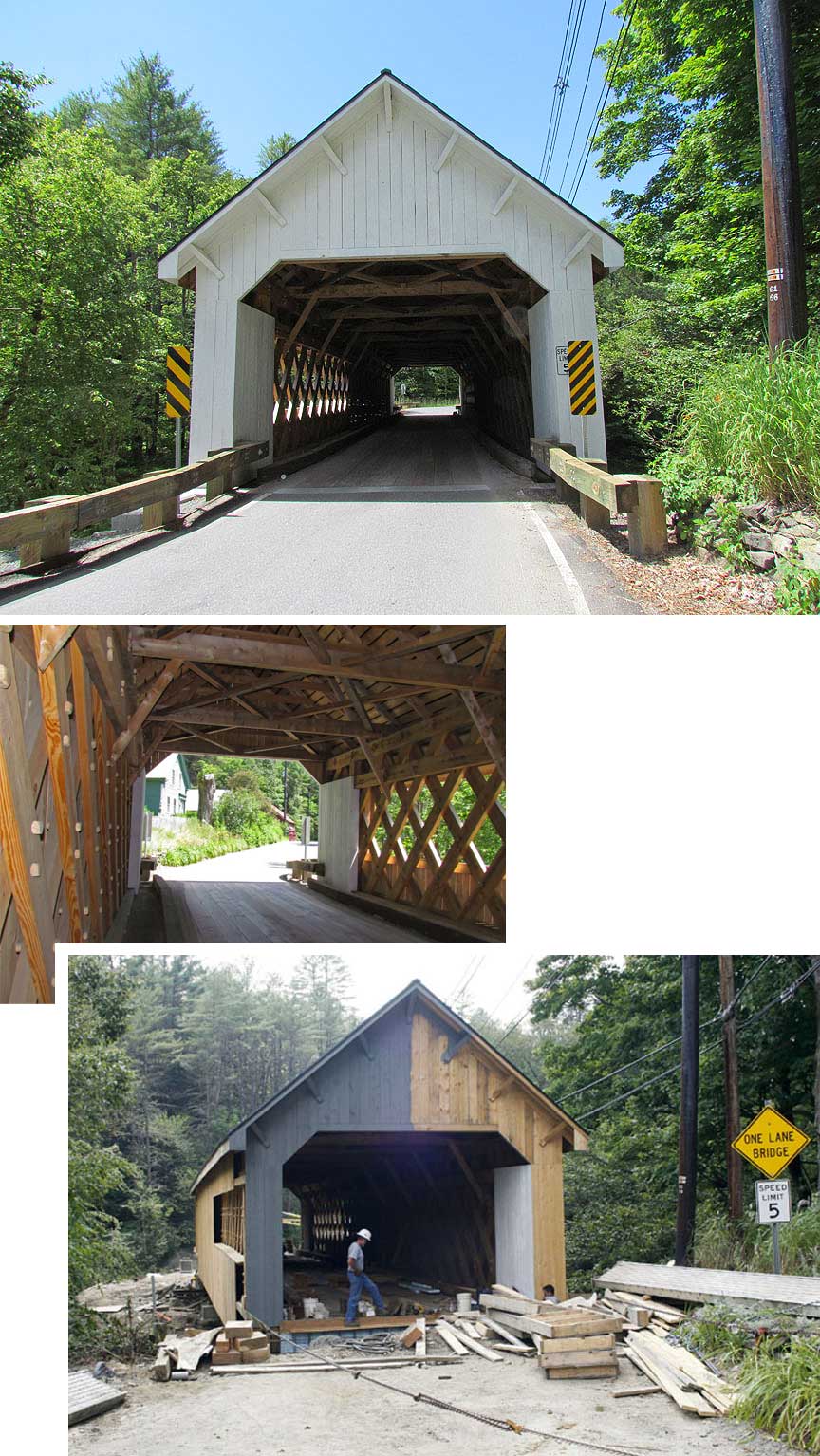
Williamville/Newfane gets a NEW COVERED BRIDGE... photos also by Galen Frysinger
SAXTON-RIVER
| 45-13-07 #2 |
East of Saxton-River on Paradise Hill Road À l'est de Saxton-River sur le chemin Paradise Hill Östlich des Dorf von Saxton-River auf Paradise Hill Straße |
Saxtons River Rivière Saxtons Saxtons Fluß |
Hall, Barber Park or Osgoode Bridge Pont couvert Hall, du parc Barber ou Osgoode Hall, Barber Park oder Brücke Osgoode |
3.2 miles WNW of jct US 5 at Bellows Falls on VT 121 then just right 3.2 miles ouest-nord-ouest de la US5 à Bellows-Falls sur la VT121 et à droite 3,2 Meilen Westnorden westlich von jct US 5 am Bellows-Falls auf VT 121 dann recht |
1 | 120' 36.5m |
Built around 1870, rebuilt in 1982 by Milton S. Gratton Construit autour de 1870, reconstruit en 1982 par Milton S. Gratton Errichtetes herum 1870, umgebaut 1982 durch Milton S. Gratton |
Town lattice Treillis Town Town Träger |
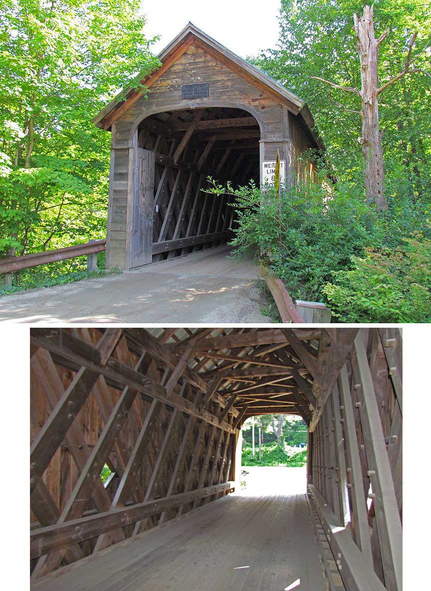
The Hall covered bridge near Saxtons-River Vt., photos from Galen Frysinger
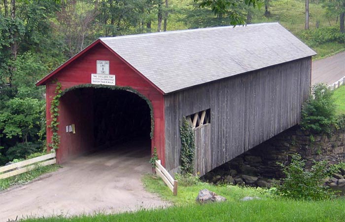
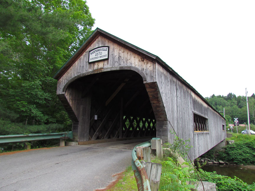
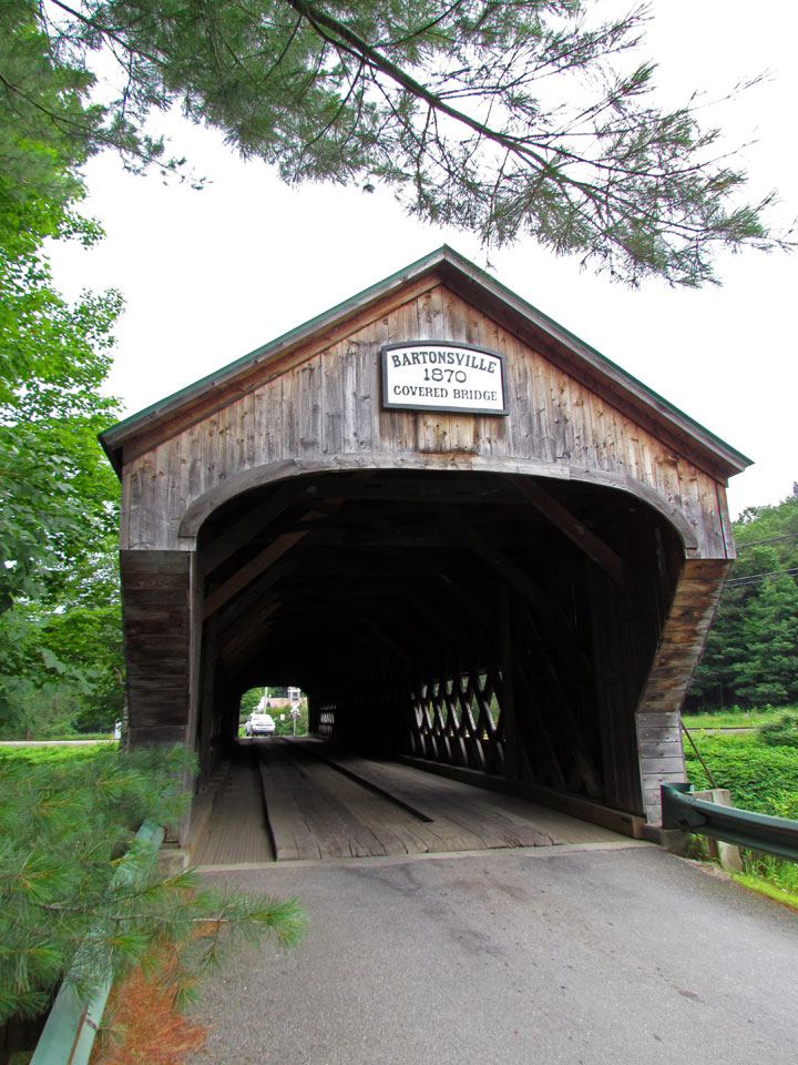
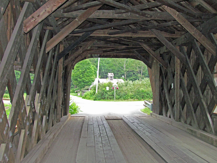
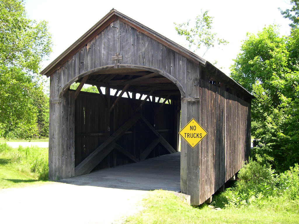
BARTONSVILLE
| 45-13-10 |
South of Bartonsville off VT 103 Au sud de Bartonsville près de la VT103 Süden von Bartonsville neben VT103 |
Williams River Rivière Williams Williams Fluß |
Worrall Covered Bridge Pont couvert Worrall Holzbrücke Worrall |
4.5 miles SE of jct of VT 11 at Chester on VT 103 then right 0.2 mile on Lower Bartonsville Road to the bridge 4.5 miles au sud est de la VT11 à Chester sur la VT103 et à droite 0.2 mile sur le chemin Lower Bartonsville 4,5 Meilen Südosten von jct von VT11 in Chester auf VT 103 dann rechts 0,2 Meile auf untererer Straße Bartonsville zur Brücke |
1 | 86' 26.2m |
Built in 1868 by Sanford Granger, restored in 2010 Construit en 1868 by Sanford Granger, restaurer en 2010 Gebaut in 1868 durch Sanford Granger, restoriert im Jahre 2010 |
Town lattice Treillis Town Town Träger |
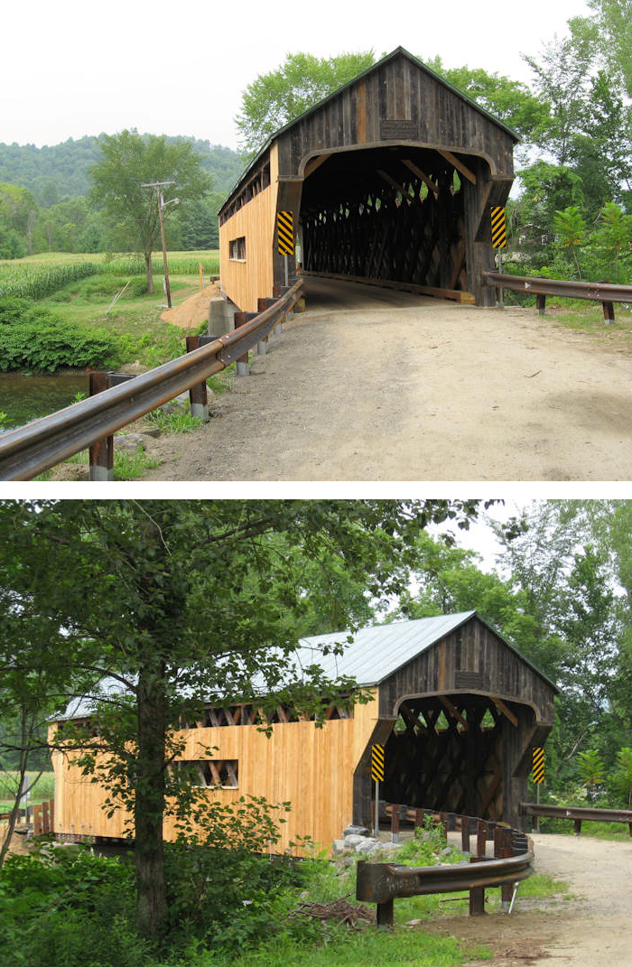
The Worrall covered bridge near Bartonsville Vt., photos by Ray Hitchcock.
| 45-13-11 |
At the south edge of Bartonsville off VT103 À la limite sud de Bartonsville près de la VT103 Am Südrand von Bartonsville neben VT103 |
Williams River Rivière Williams Williams Fluß |
Bartonsville Bridge Pont couvert de Bartonsville Holzbrücke Bartonsville |
4 miles SE of jct VT 11 at Chester on VT103 then left 0.2 mile on Pleasant Valley Road to the bridge À 4 miles au sud est de la VT11 à Chester sur la VT103 et à gauche 0.2 mile sur le chemin Pleasant-Valley vers le pont 4 Meilen Südosten von jct von VT11 in Chester auf VT 103 dann link 0,2 Meile auf Weg Pleasant-Valley zur Brücke |
1 | 158' 48.1m |
Built in 1871 by Sanford Granger, destroyed by Hurrican Irene's flood waters August 28, 2011 Construit en 1871 par Sanford Granger, emporter par la crue des eaux de l'ouragan Irène le 28 août 2011 Gebaut in 1871 von Sanford Granger, zerstört durch Hurrican Irenes Hochwasser 28. August 2011 |
Town lattice Treillis Town Town Träger |
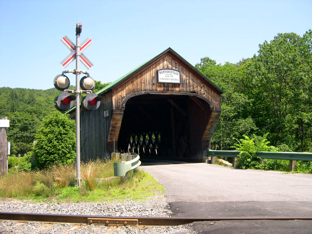
Above, the Bartonsville covered bridge, photo by Robert W. Folk
All above pictures from Galen Frysinger...
Below, after the disaster, foto Will Truax
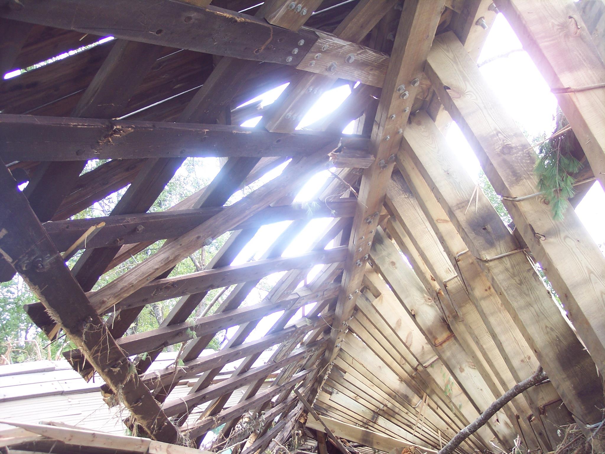
La culbutte du pont de Bartonsville au Vermont. Die neue Position des Bartonsville Brücke in Vermont. Foto Will Truax.
TOWNSHEND
| 45-13-13 |
West of Townshend off VT 30 À l'ouest de Townshend en bordure de la VT30 Westlich von Townshend neben |
West River Rivière Ouest (West) West Fluß |
Scott Bridge, closed to motor traffic Pont couvert Scott, fermé aux véhicules moteurs Holzbrücke Scott, Verbot an den motorisierten Fahrzeugen |
4.5 miles SE of jct VT 100 at East-Jamaica on VT 30 then just right 4.5 miles au sud est de la VT100 à East-Jamaica sur la VT30 et à votre droite 4,5 Meilen Südosten von jct VT 100 bei Osten-Jamaika auf VT 30 dann rechts |
3 | 290' 88.3m |
Built in 1870 by Harrison Chamberlin Construit en 1870 par Harrison Chamberlin Errichtet 1870 durch Harrison Chamberlin |
Town & King truss Treillis Town avec ferme King Town Träger mit Kingbinder |
The Scott covered bridge near Townshend Vt., photos by www.tc2u.com
ROCKINGHAM
| 45-13-23 |
NW edge of Rockingham off VT 103 À la limite nord oues de Rockingham en bordure de la VT103 Nordwestrand von Rockingham neben Weg VT 103 |
Rock Brook Ruisseau Rocheux Felsen Bach |
Victorian Village Bridge, private Pont couvert du village Victorien, privé Holzbrücke von Dorf Victorien, privat |
2.2 miles NW jct I-91 at exit 6 on VT 103 then just left at Vermont Country Store 2.2 miles au nord ouest de l'autoroute I-91 sortie 6 sur la VT103 et à votre gauche au Magasin General (Vermont Country Store) 2,2 Meilen Nordwesten von I-91 Ausgang 6 auf VT 103 dann linke am Vermontlandspeicher |
1 | 46' 14m |
Built in 1967 with timber from 45-13-12 Reconstruit en 1967 avec les restes du pont 45-13-12 Errichtet 1967 mit Bauholz von 45-13-12 |
King post truss Ferme King King Träger |
The Victorian Village covered bridge at Rockingham, photo Robert W. Folk
EAST-WILMINGTON
| 45-13-24 |
North East of Wilmington Au nord est de Wilmington Norden östlich von Wilmington |
Stowe Brook Ruisseau Stowe Bach Stowe |
High-Mowing or Twin Silos covered bridge Pont couvert de la haute-récolte ou des silos doubles Hoch-Mähende oder Doppelsilos bedeckten Brücke |
1.5 miles north east of VT9 off VT100 and then right onto Stowe Hill Road 1 1/2 mile au nord est de la VT9 sur la VT100 et tout droit sur le chemin Stowe Hill 1,5 Meilen Nord östlich VT9 auf VT100 dann rechts auf Hügelstraße Stowe (Stowe Hill Road) |
1 |
22' 6.7m |
Built in 1949 by the Haynes Brothers Construit en 1949 par les frères Haynes Errichtet 1949 durch die Haynesbrüder |
Town lattice Treillis Town Town Träger |
High-Mowing or Twin Silos covered bridge near Wilmington Vermont,photo from Galen Frysinger
GRAFTON
| 45-13-E |
South west of Grafton off Townshend Road Au sud ouest de Grafton en bordure de la route Townshend Süden westlich von Grafton neben Straße Townshend |
South Branch of the Saxton River Branche sud de la rivière Saxton Südniederlassung des Flusses Saxton |
The Grafton Cheese Factory Covered Bridge Pont couvert de la fromagerie de Grafton Die Käsefabrik Grafton Bedeckte Holzbrücke |
0.5 mile south west VT121 Main Street in Grafton on the east side of Townshend road 1/2 mile au sud ouest de la VT121 Rue Main (Principale) à Grafton du côté est de la route Townshend 0,5-Meilen-Südwest-Hauptstraße (Main St,) VT121 in Grafton auf der Ostseite der Straße Townshend |
1 | 62' 18.8m |
Built in 1967 by the Windham Foundation Construit en 1967 par la fondation Windham Errichtet 1967 durch die Grundlage Windham |
Stringer Poutre continue Tragbalken |
The Grafton Cheese Factory Covered Bridge, a very popular spot, photo from Galen Frysinger
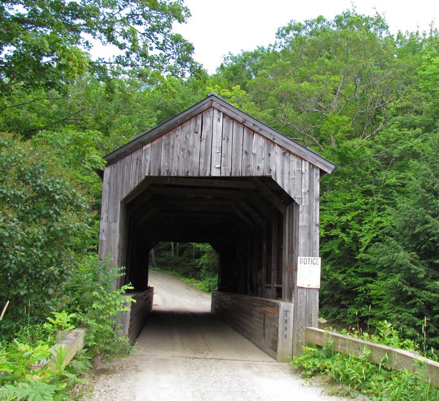
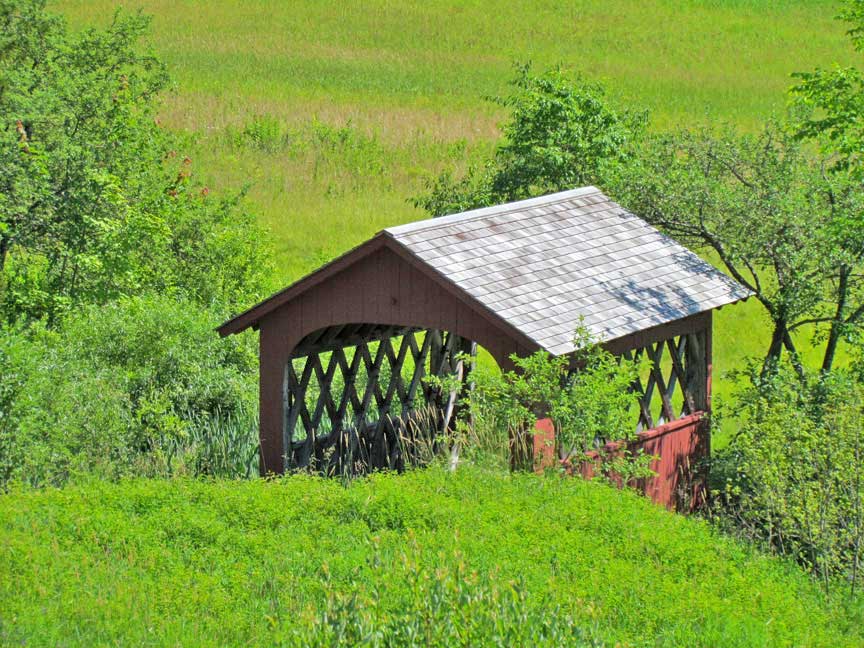
BONDSVILLE
| 45-13-P |
In the town of Bondsville Dans la petite ville de Bondsville In der Stadt von Bondsville |
Over a ski trail or gully (summer time) Au dessus d'une descente de ski, un petit ravin en été Über einer Skispur oder einem Sinkkasten (Sommerzeit) |
Snow covered bridge Pont couvert des neiges Schnee bedeckte Holzbrücke |
On access road to townhouses at Stratton Mountain Ski Area. The bridge is in Stratton, in the town of Bondsville Sur le chemin d'accès des condo du centre de ski de Stratton, à Bondsville Auf Zufuhrstraße zu den Stadtwohnungen am skibereich Stratton Gebirgs. Die Brücke ist in Stratton, in der Stadt von Bondsville |
1 |
50' 15.2m |
No building date given Pas de date de construction Nicht ein bestimmtes Konstruktionsdatum |
Steel Stringer Poutre continue en acier Stahltragbalken |
The Stratton Mountain Ski Area Covered Bridge in Bondsville, photo Joe Nelson
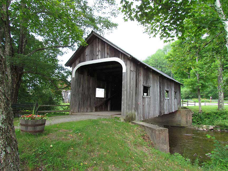
WEST-DOVER
|
45-13-25 |
At 25 Handle Road in West-Dover Au 25 du chemin Handle à Dover-Ouest Am 25 Handle Weg in Dover-West |
Cold Brook Ruisseau Froid Calt Bach |
Hermitage Road covered bridge, privata, Hermitage Inn owned by Donna and Jim Barnes Pont couvert privé de l'auberge Hermitage, Donna et Jim Barnes propriétaires Hermitage Gasthaus Holzbrücke, privat, Donna und Jim Barnes Besitz |
About 8.5 miles north of VT9 on VT100 and then left onto Tannery Road and left again on Handle Road to the Heritage Inn at no. 25 on the right side of the road About 8.5 mile au nord est de la VT9 sur la VT100 et tout droit sur le chemin Tannery et à gauche jusqu'à 25 de la route Handle à l'auberge Héritage sur le côté droit de la route Ungefähr 8,5 Meilen Nordlich VT9 auf VT100 dann links auf Tannery (Gerberei) Straße und links auf Handle Straße zu No.25 am Heritage Gasthaus |
1 |
60' 18.2m |
Built in 2009, designed by John Guminak of Dover Vt Construit en 2009 et dessiner par John Guminak de Dover Erbaut im Jahr 2009, von John Guminak von Dover Vt konzipiert |
Town lattice Treillis Town Town Träger |
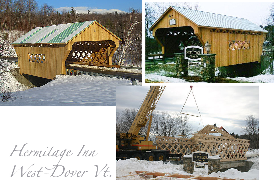
Photos by Anita Rafael and Rob Wadsworth