ponts couverts dans le monde
bedeckte Brücken der Welt
世界各地的棚桥

14-61
PARKE county/comté/grafschaft
32 covered bridges/ponts couverts/bedeckte Holzbrücken
![]()
This symbol indicates this listing has been translated from English to French
and German by ATAWALK
Ce symbole indique que la traduction de cette liste fut effectuer à partir
de l'anglais au Français et à l'Allemand par ATAWALK
Dieses Symbol deutet darauf hin, dass diese Auflistung von ATAWALK vom Englischen
ins Französische und Deutsche übersetzt wurde.

Parke county is home to the largest covered
bridge Festival in the world.
the link above will take you there.
Le comté de Parke est le site du plus gros
festival de ponts couverts au monde,
le lien ci-haut vous y conduit directement.
Parke
Grafschaft ist die Heimat der größte
bedeckte Holzbrücke Festival in der Welt.
Den obigen Link gelangen Sie es.
|
14-61-01
|
South east of Mansfield off CR720 south in Jackson Twp. Au sud-est de Mansfield en bordure de la CR720 sud au canton Jackson Süd-östen von Mansfield auf Süd CR720 am Jackson Landkreis |
Big Rocky Fork Creek Ruisseau de la branche des grosses roches Große Steiner Nebenfluß Bach |
Big Rocky Fork Bridge, Closed to motor traffic Pont couvert de la branche des grosses roches, fermé au traffic moteur Große Steiner Nebenfluß Holzbrücke, Fahrzeugverkehr verboten |
1.5 miles east of IN59 south of Mansfield on CR720, Greencastle Road, on the left side of the road 1.5 miles à l'est de la IN59 au sud de Mansfield sur la CR720, route de Greencastle, du côté gauche de la route 1,5 km östlich von IN59 südlich von Mansfield auf CR720, Grünschloss Straße, auf der linken Seite der Straße |
1 |
72' 32.9m |
Built in 1900 by J. J. Daniels Construiit en 1900 par J. J. Daniels Gebaut in 1900 von J. J. Daniels |
Burr/Arch truss Ferme Burr avec arches Burr Träger mit Bogen |
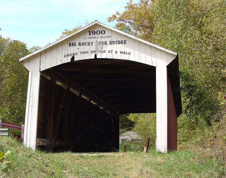
The Big Rocky Fork bridge near Mansfield 14-61-01, photo Galen Frysinger.
|
14-61-02
|
SW of the village of Mansfield on CR 550 East in Raccoon Twp. Au sud-ouest du village de Mansfield sur la CR550 est dans le canton Raccoon Süd-westlich von des Dorf Mansfield auf CR550 am Waschbären Landkreis |
Big Raccoon Creek Grosse rivière aux Ratons-Laveurs Große Waschbären Fluß |
Conley's Ford Bridge Pont couvert du Gué des Conleys Conley Furt Holzbrücke |
1 miles west of IN 59 on CR 720, Greencastle Road, then right at "T" on CR550 for 0.2 mile to the bridge 1 mile à l'ouest de la IN59 sur le chemin de Greencastl et à droite au "T" sur CR550 0.2 mile vers le pont 1 km westlich des IN59 auf CR 720, Greencastle Straße, dann rechts auf "T" für 0,2 Meilen am der CR550 zum die Brücke |
1 |
192' 58.5m |
Built in 1906 by J. L. Van Fossen Construit en 1906 par J.L. Van Fossen Gebaut in 1906 von J.L. Van Fossen |
Burr/Arch truss Ferme Burr avec arches Burr Träger mit Bogen |
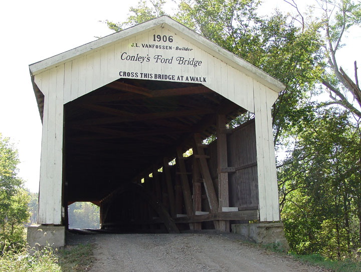
The Conley Ford bridge near Mansfield 14-61-02, photo Galen Frysinger.
| 14-61-04 (PC 08) |
In the Village of Bridgeton Au village de Brudgeton In des Dorf von Bridgeton |
Big Raccoon Creek Grosse rivière aux Ratons-Laveurs Große Waschbären Fluß |
The New Bridgeton Covered Bridge, closed to motor traffic Le nouveau pont couvert de Bridgeton, ouvert au traffic piétonnier seulement Die Neue Bridgeton Holzbrücke, |
About 7 miles south of Rockville and US36 on CR29 Bridgeton Road to CR 80S to CR 780S to the Village of Bridgeton, right next to the old mill at north edge of the village off CR 320 East Environ 7 miles au sud de la US 35 à Rockville sur la CR29 et la CR80s, chemin de Bridgeton jusqu'à la CR780s, à gauche vers le village, le pont sera du côté droit de la CR320-est, à l'entré nord de Bridgeton. Etwa 7 km südlich von Rockville und US36 auf CR29 Bridgeton Road to CR 80S zu CR 780S zum Dorf Bridgeton, direkt neben der alten Mühle in Norden Rande des Dorfes off CR 320 Osten |
2 | 245' 74.6m |
Built in 1868 by J.J. Daniels, arsoned in 2005, rebuilt in 2006
Construiit en 1900 par J. J. Daniels, incendié en 2005, reconstruit en 2006 Gebaut in 1900 von J. J. Daniels, zerstört von einem kriminellen Brand in 2005, wieder gebaut in 2006 |
Burr/Arch truss Ferme Burr avec arches Burr Träger mit Bogen |
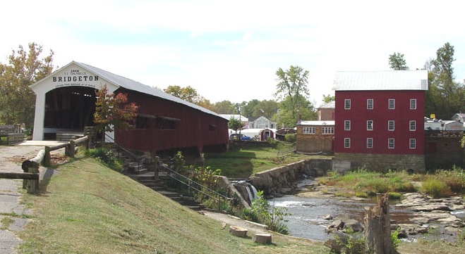
The original Bridgeton span, 1868-2005, photo Galen Frysinger
Das alte Bridgeton brücke 1868, 2005... le vieux pont couvert de Bridgeton.
The NEW Bridgeton covered bridge 14-61-04, click here for reconstruction story
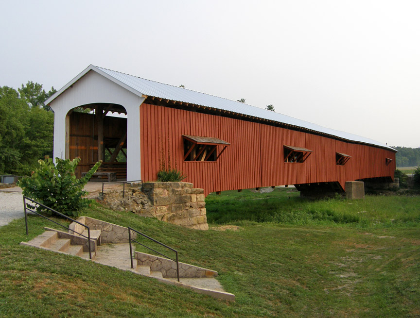
The stunning new Bridgeton covered bridge, built in 2006,
photo Galen Frysinger
Le nouveau pont couvert de Bridgeton, das neue Bridgeton
Holzbrücke.
Note: The Bridgeton is listed here as original for it was
re-built at the same location, by the poeple of the region and right after
it's destruction
which is like many other bridges destroyed in Canada, Europe and the USA
which today are simply considered original altho it is well documented that
at one time, they had to be rebuilt. Buren an der Aare Switzerland, Bridgeton
Indiana, and Point-Wolfe in Canada are examples
If the Bridgeton had been rebuit 10 years after it's demise, like many
other bridges in Canada, Europe and the USA... then it would be a Replica,
Wakefield, Quebec, Dresden Germany, those are but two examples.
If continuation exist and a structure is promptly replaced within reasonnable
delays, it should always be listed AS AUTHENTIC in a show of respect for the
builders and to encourage such events to occur more often.
Other excuses NOT TO list the present structure as AUTHENTIC
should therefore be strongly opposed!
| 14-61-05 (PC 14) |
South-east of Catlin on CR 170 East in Raccoon Twp. Au sud-est de Catlin sur la CR170 dans le canton Raccoon Süd-östen von Catliin auf CR170 am Waschbären Landkreis |
Little Raccoon Creek Petite rivière aux Ratons Kleine Waschbären Fluß |
Nevins Bridge Pont couvert Nevins Nevins Holzbrücke |
About 5 miles south of US36 at Rockville down CR40 to Catlin then east 1.2 miles east to CR 130E, 0.6 mile right to the bridge Environ 5 miles au sud de la US36 à Rockville sur la CR40 jusqu'à Catlin et vers l'est jusqu'à la CR130, à droite o.6 mile vers le pont Etwa 5 km südlich von US36 in Rockville auf CR40 zu Catlin dann östlich 1,2 Meilen zu CR130E, 0,6 Meilen Recht zum die Brücke |
1 | 155' 47.2 |
Built in 1920 by J. A. Britton Construit en 1920 par J. A. Britton Gebaut in 1920 von J. A. Britton |
Burr/Arch truss Ferme Burr avec arches Burr Träger mit Bogen |
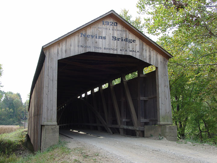
Nevins Bridge 14-61-05, photo Galen Frysinger.
| 14-61-06 (PC 10) |
North-east of Catlin on CR 160 East in Raccoon Twp Au nord-est de Catlin sur la CR160-est dans le canton Raccoon Nord-östen von Catlin auf CR160-öst am Waschbären Landkreis |
Little Raccoon Creek Petite rivière aux Ratons Kleine Waschbären Fluß |
Neet Bridge, now closed to motor traffic Pont couverrt Neet, maintenant fermé au traffic moteur Neet Holzbrücke, |
East of Catlin south of CR400 on CR80 and left on CR160 East, 0.5 mile to the bridge À l'est de Catlin au sud dela CR400 sur la CR80 et à gauche 0.5 mile sur la CR160 vers le pont. Östlich von Catlin südlich von CR400 auf CR80 und links auf CR160 Osten, 0,5 Meilen auf der Brücke |
1 | 126' 38.4m |
Built in 1904 by J. J. Daniels Construit en 1904 par J. J. Daniels Gebaut in 1904 van J. J. Daniels |
Burr/Arch truss Ferme Burr avec arches Burr Träger mit Bogen |
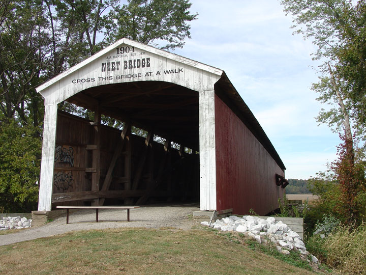
The Neet Bridge 14-61-06, photo Galen Frysinger.
| 14-61-07
|
North east of Rosedale off CR 40 East in Florida Twp. Au nord-est de Rosedale en bordure de la CR40 dans le canton Floride Nord-östen von Rosedale auf CR40 am Florida Landkreis |
Big Raccoon Creek Grosse rivière aux Ratons-Laveurs Große Waschbären Fluß |
Thorpe Ford Bridge, closed to motor traffic Pont couvert du gué Thorpe, fermé au traffic moteur Thorpe Furt Holzbrücke, Fahrzeugverkehr verboten |
0.3 miles east of CR550 North MainStreet at Rosedale on Central Street, left on Cemetery Street to CR 40 E, Catlin-Rosedale Road about 1.5 miles to the bridge 0.3 mile à l'est de la CR550 à Rosedale sur la rue Centrale, à gauche sur la rue du Cimetière, et sur le chemin Catlin-Rosedale CR40 1.5 miles jusqu'au pont 0,3 km östlich von CR550 North Hauptstraße in Rosedale am Zentrum Straße, links in die Friedhof Straße zu CR 40 E, Catlin-Rosedale Weg 1,5 Meilen zum die Brücke |
1 | 163' 49.6m |
Built in 1912 by J. A. Britton Construit en 1912 par J. A. Britton Gebaut in 1912 von J. A. Britton |
Burr/Arch truss Ferme Burr avec arches Burr Träger mit Bogen |
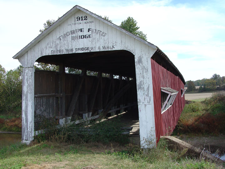
The Thorpe Ford Covered Bridge 14-61-07, photo ATAWALK October 1994.
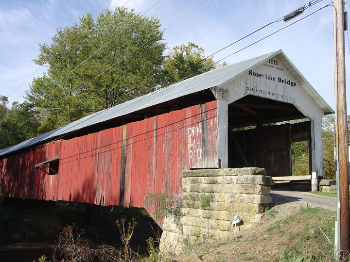
| 14-61-09 (PC 18) |
At Coxville just off CR 550 W in Florida Twp. À Coxville en bordure de la CR550 dans le canton Floride In Coxville auf CR550 am Florida Landkreis |
Big Raccoon Creek Grosse rivière aux Ratons-Laveurs Große Waschbären Fluß |
Roseville or Coxville Bridge Pont couvert de Roseville ou Coxville Rosedale oder Coxville Holzbrücke |
About 2 miles north of Rosedale to Coxville on CR 550, then right at CR325 to the bridge. Environ 2 miles au nord de Rosedale to Coxville sur la CR550, et à droite sur la CR325 vers le pont. Etwa 2 km nördlich von Rosedale zu Coxville auf CR 550, dann rechts auf CR325 zum die Brücke. |
2 | 263' 80.1m |
Built in 1910 by J. L. Van Fossen Construit en 1910 par J.L. Van Fossen Erbaut im Jahr 1910 von J. L. Van Fossen |
Burr/Arch truss Ferme Burr avec arches Burr Träger mit Bogen |
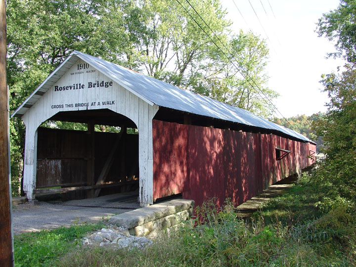
The two different portals of the Roseville covered bridge 14-61-09 with the AT A WALK sign, photos Galen Frysinger
| 14-61-10 (PC 19) |
North-west of Coxville on CR 500 S in Florida Twp. Au nord-ouest de Coxville sur la CR500 S dans le canton Floride Nord-westen von Caxville auf CR500s am Florida Landkreis |
Over Rock Run Au rapide de la roche Am der Steiner Bach |
Harry Evans Bridge Pont couvert Harry Evans. Harry Evans Holzbrücke |
0.4 mile north of CR 550w at Coxville on CR 325 W then 0.6 mile to bridge 0.4 mile au nord de la CR550 à Coxville sur la CR325 et 0.6 mile vers le pont 0,4 Meilen nördlich von CR 550W bei Coxville über CR 325 W dann 0,6 Meilen nach Brücke |
1 | 65' 19.8m |
Built in 1908 by J. A. Britton Construit en 1908 par J. A. Britton Gebaut in 1908 von J. A. Britton |
Burr/Arch truss Ferme Burr avec arches Burr Träger mit Bogen |
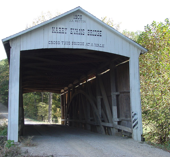
The Harry Evans covered bridge 14-61-10, by Galen Frysinger.
| 14-61-11 (PC 20) |
North-west of Coxville on CR 500 S in Florida Twp. Au nord-ouest de Coxville sur la CR500 S dans le canton Floride Nord-westen von Caxville auf CR500s am Florida Landkreis |
Over Rock Run Au rapide de la roche Am der Steiner Bach |
Zacke Cox Bridge Pont couvert Zacke Cox Zacke Cox Holzbrücke |
0.4 mile north of CR 550w at Coxville on CR 325 W 3.2 mile and right 0.4 mile to bridge 0.4 mile au nord de la CR550 à Coxville sur la CR325 pour 3.2 miles et à droite 0.4 vers le pont 0,4 Meilen nördlich von CR 550W bei Coxville auf CR 325 W 3.2 Meilen dann Recht 0.4 Mielen nach Brücke |
1 | 54' 16.4m |
Built in 1908 by J. A. Britton, arconed in 1999, rebuilt in 2000. Construit en 1908 par J. A. Britton, détruit par un incendie criminel en 1999, reconstruit en 2000. Gebaut in 1908 von J. A. Britton, zerstört von einem kriminellen Brand in 1999, wieder gebaut in 2000. |
Burr/Arch truss Ferme Burr avec arches Burr Träger mit Bogen |
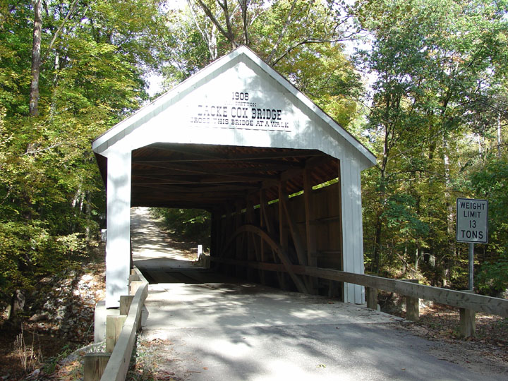
The restored Zacke Cox bridge near Coxville 14-61-11, photo Galen Frysinger.
Note: The Zacke Cox is listed here as original for it was
re-built at the same location, by the poeple of the region and right after
it's destruction
which is like many other bridges destroyed in Canada, Europe and the USA
which today are simply considered original altho it is well documented that
at one time, they had to be rebuilt. Buren an der Aare Switzerland, Bridgeton
Indiana, and Point-Wolfe in Canada are examples
If the Zacke Cox had been rebuit 10 years after it's demise, like many
other bridges in Canada, Europe and the USA... then it would be a Replica,
Wakefield, Quebec, Dresden Germany, those are but two examples.
If continuation exist and a structure is promptly replaced within reasonnable
delays, it should always be listed AS AUTHENTIC in a show of respect for the
builders and to encourage such events to occur more often.
Other excuses NOT TO list the present structure as AUTHENTIC
should therefore be strongly opposed!
| 14-61-12 (PC 22) |
South east of Montezuma on old US35 at CR 420 W in Wabash Twp. Au sud-est de Montezuma du long de la vieille US36 à la CR420 dans le canton Wabash Süd-östen von Montezuma bei alte US36 auf CR420 am Wabash Landkreis |
Big Pond Creek Ruisseau du grand étang Große Teich Bach |
Phillips Bridge Pont couvert Phillips Phillips Holzbrücke |
2.5 miles east of Montezuma on US36 and right on CR310, the old US36, for 0.7 miles then 0.1 right 2.5 miles à l'est de Montezuma sur la CR310, la vieille US36, 0.7 mile et à droite 0.1 vers le pont 2,5 Mielen östlich von Montezuma auf US36 und rechts auf CR310, der alten US36, für 0,7 Meilen dann 0,1 rechts |
1 | 43' 13.1m |
Built in 1909 by J. A. Britton Construit en 1909 par J. A. Britton Gebaut in 1909 von J. A. Britton |
Multiple King Post truss Ferme à pointçons multiples Mehrfache Einfache Hängewerk |
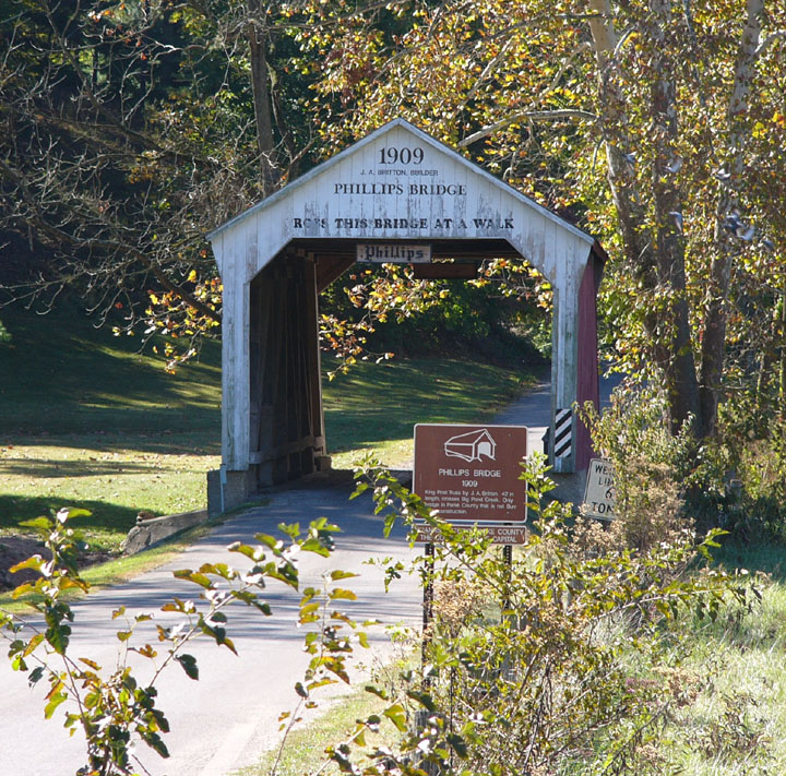
The Phillips bridge near Montezuma 14-61-12, photo Galen
Frysinger.
The shortest bridge in Parke county, le pont couvert le plus court du comté,
Die kürzeste Brücke in Parke Grafschaft
| 14-61-13 (PC 21) |
Western edge of Mecca À la limite ouest de Mecca Westlichen Rand von Mecca |
Big Raccoon Creek Grosse rivière aux Ratons-Laveurs Große Waschbären Fluß |
Mecca Bridge, closed to motor traffic Pont couvert de Mecca. fermé au traffic moteur Mecca Holzbrücke, Fahrzeugverkehr verboten |
About 6 miles south-west of Rockville off US41 to CR260 and just off CR 550 W along the river at Mecca Environ 6 miles au sud-ouest de Rockville sur la US41 et la CR260 et en burdure de la CD550 au village de Mecca Ungefahr 6 Meilen süd-westlich von Rockville off US41 zu CR260 und CR 550 W entlang des Flusses in Mekka |
1 | 150' 45.7 |
Built in 1873 by J. J. Daniels Construit en 1873 par J. J. Daniels Gebaut in 1873 van J. J. Daniels |
Burr/Arch truss Ferme Burr avec arches Burr Träger mit Bogen |
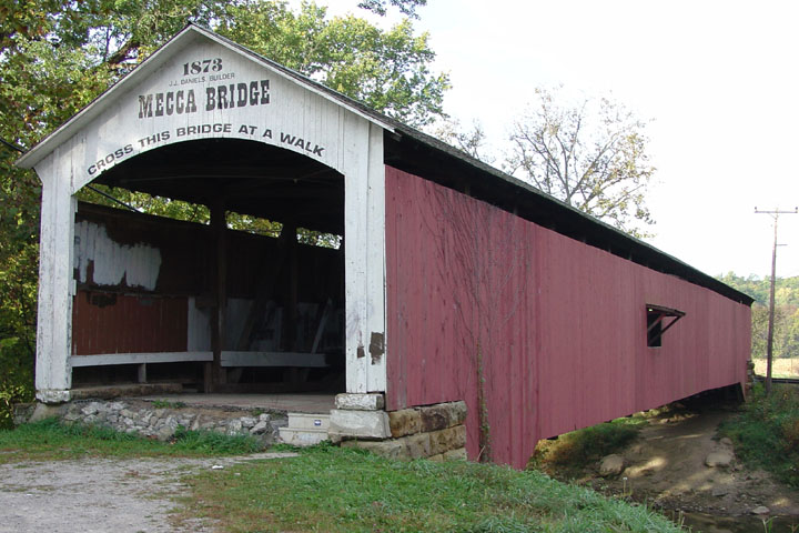
The Mecca covered bridge 14-61-13, photo Galen Frysinger.
| 14-61-14 (PC 23) |
South east of Montezuma on old US36 Au sud de Montezuma Süd-öten von Montezuma auf alt US36 |
Leatherwood Creek Ruisseau Leatherwood Leatherwood Bach |
Sim Smith Bridge Pont couvert Sim Smith Sim Smith Holzbrücke |
2.5 East of Montezuma on US 36 than right 0.2 miles on old US 36 to the bridge 2.5 miles à l'est de Montezuma par la US36, à droite sur la vieille US36 0.2 mile vers le pont 2.5 Mielen Östlich von Montezuma auf 36US, recht als 0,2 Meilen auf alten US-36 bis die Brücke |
1 | 84' 25.6m |
Built in 1883 by J. A. Britton Construit en 1883 par J. A. Britton Gebaut in 1883 von J. A. Britton |
Burr/Arch truss Ferme Burr avec arches Burr Träger mit Bogen |
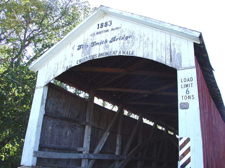
The Sim Smith bridge near Montezuma 14-61-14, photo Galen Frysinger.
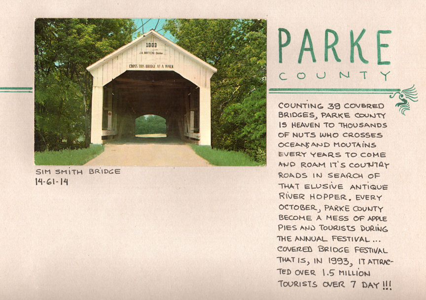
The first postcard I ever found of a bridge in Parke county
Indiana, it mentioned a "Covered bridge festival"???
How could
that be?
| 14-61-15 (PC 13) |
Just North of Rockville off US41 on County Golf Course in Adams Twp. Juste au nord de Rockville au club de golf du comté en bordure de la US41 dans la canton Adams. Nördlich von Rockville auf US41 am County Golf Course in Adams Landkreis. |
Bill Diddle Creek Ruisseau Bill Diddle Bill Diddle Bach |
Catlin Bridge Pont couvert de Catlin Catlin Holzbrücke |
1.6 miles north of jct US 36 in Rockville on US 41, the bridge is on Golf course on the west side of the road 1.6 miles de la US36 sur la US41, du côté ouest de la route sur un champ de golf. 1.6 Mielen von US36 auf US41, die Brücke ist am Golfplatz auf der Westseite der Straße |
1 | 54' 16.4m |
Built in 1907 by Clark McDaniels, moved there from Catlin in 1961 Construit en 1907 par Clark McDaniels, déménagé de Catlin à Rockville en 1961 Gebaut in 1907 von Clark McDaniels, zog es aus Catlin zu Rockville im Jahr 1961 |
Burr/Arch truss Ferme Burr avec arches Burr Träger mit Bogen |
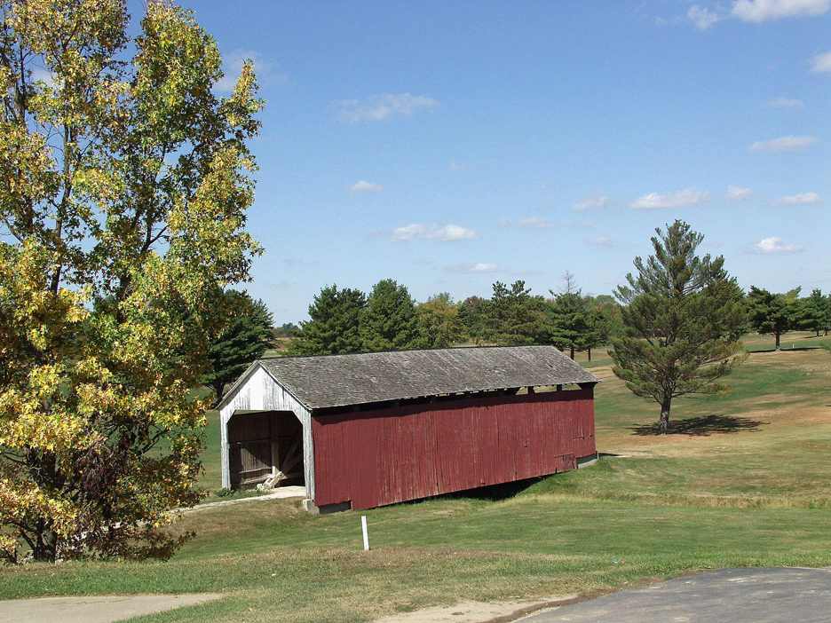
The Catlin covered bridge at the County Golf Course in Rockville, 14-61-15, photo I. Stewart.
| 14-61-16 (PC 11) |
North-east of Catlin on CR 400 S in Adams Twp. Au nord-est de Catlin sur la CR400s dans le canton Adams Nord-östlich von Catlin auf CR 400 S in Adams Landkreis. |
Little Raccoon Creek Petite rivière aux Ratons-Laveurs Kleine Waschbären Fluß |
McAllister Bridge Pont couvert McAllister McAllister Holzbrücke |
1.2 miles east of CR40 at Catlin on CR500 to CR130 left 0.8 mile to CR400 S then right past CR29 to the bridge 1.2 miles à l'est de catlin sur la CR500 vers la CR130 à gauche jusqu'à la CR 400, à droite, passer la CR29 jusqu'au pont 1,2 km östlich von CR40 auf Catlin auf CR500 zu CR130 links 0,8 Meilen zu CR400 S dann rechten Vergangenheit CR29 zum die Brücke |
1 | 126' 38.4m |
Built in 1914 by J. A. Britton Construit en 1914 par J. A. Britton Gebaut in 1914 von J. A. Britton |
Burr/Arch truss Ferme Burr avec arches Burr Träger mit Bogen |
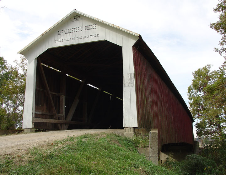
The McAllister bridge east of Catlin 14-61-16, photo ATAWALK October 1994.
| 14-61-17 (PC 12) |
South east of Rockville on CR 225 E in Adams Twp. Au sud-est de Rockville en sur la CR225 à la CR275 Süd-östlich von Rockville über CR 225 E in Adams Landkreis. |
Williams Creek Ruisseau Williams Williams back |
Crooks Bridge Ponts couvert Crooks Crooks Holzbrücke |
About 5 miles south from Rockville on CR29 left on CR160 S to CR 225E right then south to CR275 at the bridge Environ 5 miles au sud de Rockville sur CR29, à gauche sur CR160 et à droite sur la CR225 jusqu'au pont, à la CR275 Etwa 5 km südlich von Rockville auf CR29 links auf die CR160 und CR 225E rechts, dann Süden auf CR275 nach die Brücke |
1 | 132' 40.3M |
Built in 1855-56 by Gen. Arthur Patterson or Henry Wolfe ... ? Construit soit par Gen Arthur Patterson ou Henry Wolf... en 1855-56, on est pas sûre! Gebaut in 1855-56 von General Arthur Patterson oder Henry Wolf...? |
Burr/Arch truss Ferme Burr avec arches Burr Träger mit Bogen |
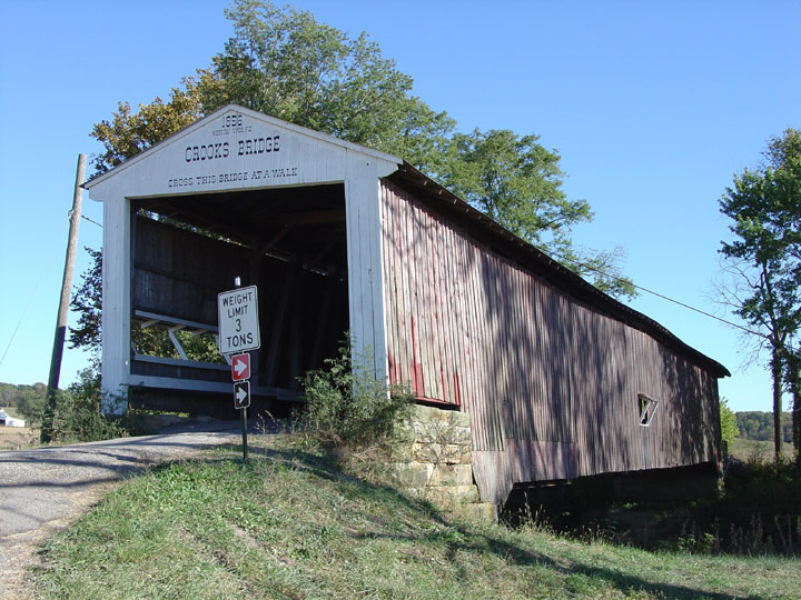
The Crooks bridge 14-61-17, photo Galen Frysinger.
| 14-61-19 (PC 39) |
East of Rockville at Billie Creek Village in Adams Twp. on old US 36 À l'est de Rockville sur la vieille US36 au village Billy Creek dans la canton Adams Östlich von Rockville an der historischen Billie Creek Village in Adams Landkreis auf alten US 36 |
Williams Creek Ruisseau Williams Williams Back |
Rockville or Billie Creek Bridge Pont couvert de Rockville ou de Billy Creek Village Rockville oder Dorf Billy Creek Holzbrücke |
At the eastern entrance to Rockville on the south side of US36 À l'entrée est de Rockville par la US36 du côté sud de la route Auf den östlichen Eingang zur Rockville an der Südseite des US36 |
1 | 62' 18.8m |
Built in 1895 by J. J. Daniels Construit en 1895 par J. J. Daniels Gebaut in 1895 von J. J. Daniels |
Burr/Arch truss Ferme Burr avec arches Burr Träger mit Bogen |
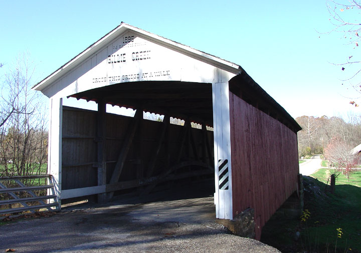
The Billie Creek Bridge 14-61-19, photo Galen Frysinger.
| 14-61-20 (PC 05) |
At the village of Mansfield on old US 59 in Jackson Twp. Sur la vieille US59 au village de Mansfield dans le canton JAckson Auf alten US59 in des Dorf von Mansfield am Landkreis Jackson |
Big Raccoon Creek Grosse rivière aux Ratons-Laveurs Große Waschbären Fluß |
Mansfield Bridge Pont couvert de Mansfield Mansfield Holzbrücke |
12 miles south-east of Rockville on US36 to Bellmore, then south on IN59 to Mansfield right in the middle of the village just south of the grist mill on old IN59, CR810. 12 miles au sud-est de Rockville sur la US36 par Bellmore et sud sur la IN59 vers Mansfield, au centre du village sur la vieille IN59, CR810 à côté du vieux moulin à farine 12 Meilen südöstlich von Rockville auf US36 zu Bellmore, dann Süden auf IN59 zu Mansfield links in der Mitte des Dorfes südlich bei die alte Mühle auf alten IN59, CR810. |
2 | 247' 75.2m |
Built in 1867 by J. J. Daniels Construit en 1867 par J. J. Daniels Gebaut in 1867 von J. J. Daniels |
Burr/Arch truss Ferme Burr avec arches Burr Träger mit Bogen |
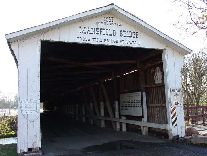
The Mansfield bridge 14-61-20, photos by Galen Frysinger.
| 14-61-21 (PC 34) |
North-east of Guion on CR 650 N in Greene Twp. Au nord-est de Guion sur CR650 au canton Green Nord-östlich von Guion auf CR650 am Kandkreis Greene |
Little Raccoon Creek Petite rivière aux Ratons-Laveurs Kleine Waschbären Fluß |
Portland Mills/Dooley Station Bridge Pont couvert de Portland Mills/Dooley Station Portland Mills/Dooley Station Holzbrücke |
11 miles north-east of Rockville on US36 to Bellmore north on IN59 to Guion, then 0.5 north-east of IN59/236 left on CR 720 E, then right on CR 650 N to the Bridge 11 miles au nord-est de Rockville par la US36 à Bellmore et la IN59 vers la IN236 à Guion, et à gauche sur la CR720 0.5 mile, a droite sur CR650 vers le pont 11 Meilen nord-östlich von Rockville auf US36 zu Bellmore Norden auf IN59 zu Guion, dann 0,5 nord-östlich auf IN59/236 links in die CR 720 E, dann rechts auf CR 650 N nach Brücke |
1 | 130' 39.6 |
Built in 1856 by Henry Wolfe at Portland Mills down the road, moved to Dooley Station in 1961, arsoned again in 1989, finally collapsed in 1995, restored by Michael Cooper and re-opened to traffic in June 1996 Construit à Portland Mills par Henry Wolfe in 1856, moved to Dooley Station in 1961, incendié à son tour en 1989, il s'écrase finallement en 1995, ill sera complètement restaurer par Michael Cooper et ré-ouvert à la ciculation en juin 1996 Erbaut im Jahr 1856 von Henry Wolfe in Portland Mills, wieder auf nach Dooley Station in 1961, zerstört von einem kriminellen Brand in 1989, schließlich zusammengebrochen in 1995, restauriert von Michael Cooper und wieder für den Verkehr freigegeben im Juni 1996 |
Burr/Arch truss Ferme Burr avec arches Burr Träger mit Bogen |
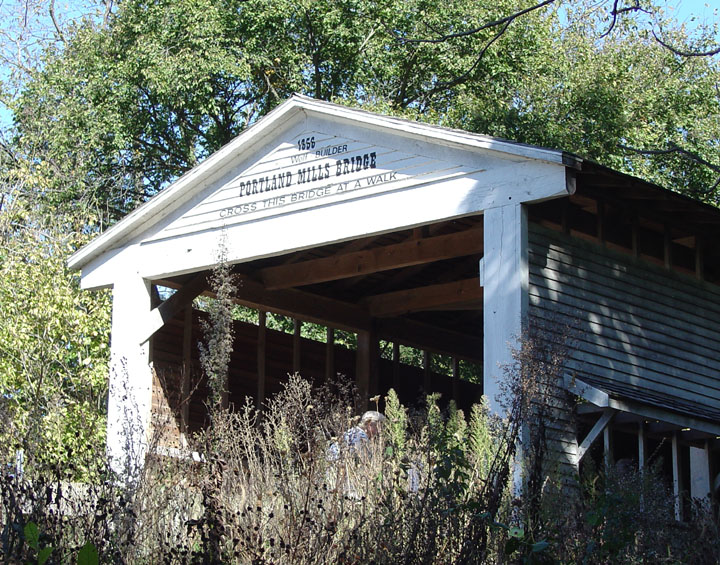
The Portland Mills bridge 14-61-21, photo Galen Frysinger.
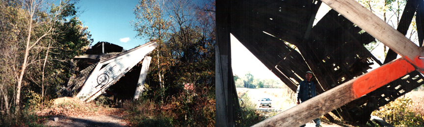
My first visit at Dooley Station in 1995... Michael Galita
and I ventured in, Carzie stayed away...
I never thought it would be saved... foto ATAWALK 1995
Dooley Station
en 1995, pour la première fois, je voyais un pont couvert écroulé...
zum ersten Mal sehe ich einen bedeckte Brücken zerstört!
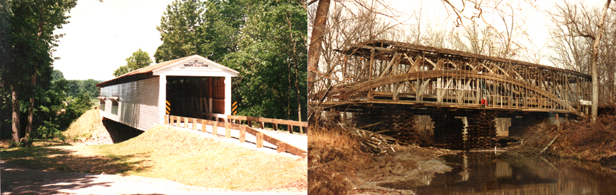
Foto Michael Cooper, 1996.
| 14-61-24 (PC 38) |
East of Rockville at Billie Creek Village in Adams Twp. on old US 36 À l'est de Rockville sur la vieille US36 au village Billy Creek dans la canton Adams Östlich von Rockville an der historischen Billie Creek Village in Adams Landkreis auf alten US 36 |
Williams Creek Ruisseau Williams Williams Bach |
Beeson Bridge Pont couvert Beeson Beeson Holzbrücke |
At the eastern entrance to Rockville on the south side of US36 À l'entrée est de Rockville par la US36 du côté sud de la route Auf den östlichen Eingang zur Rockville an der Südseite des US36 |
1 | 55' 16.7m |
Built in 1906 by Frankfort Construction on Big Raccoon Creek, moved to Billy Creek in 1980, survive two arson attempts, admission Construit en 1906 sur la Big Raccoon Creek, il survivra deux incendies criminels pour finallement être déménagé au village Billy Creek en 1980, prix d'entrée. Erbaut im Jahr 1906 durch Frankfort Konstruktion Geselschaft auf GroßeWaschbär Fluß, zwei überleben Brandstiftung versucht, wieder auf nach Billy Creek in 1980, Eintritt Preis |
Burr/Arch truss Ferme Burr avec arches Burr Träger mit Bogen |
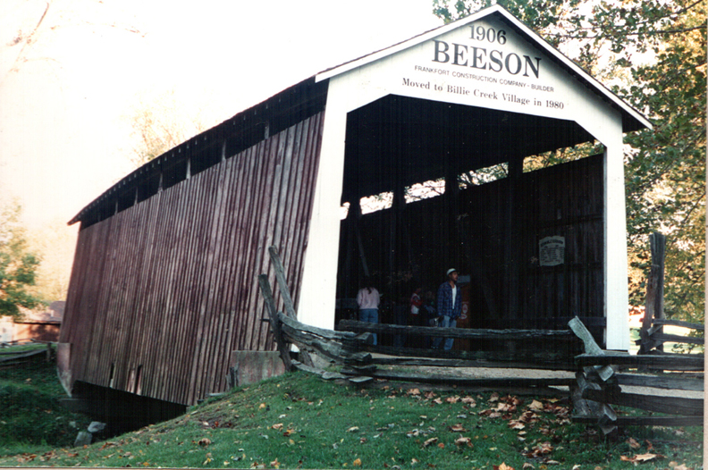
The Beeson bridge at Billie Creek Village 14-61-24, photo ATAWALK October 1994.
| 14-61-25 (PC 25) |
East of Rockville at Billie Creek Village in Adams Twp. on old US 36 À l'est de Rockville sur la vieille US36 au village Billy Creek dans la canton Adams Östlich von Rockville an der historischen Billie Creek Village in Adams Landkreis auf alten US 36 |
Williams Creek Ruisseau Williams Williams Bach |
Leatherwood Station Bridge Pont couvert de Leatherwood Station Leatherwood Station Holzbrücke |
At southern edge of Billie Creek Village off US 36, Admission À la limite sud du parc Billy Creek Am der Süden Rand des Dorf Billy Creek |
1 | 72' 21.9m |
Built in 1899 by J. A. Britton moved to Billy Creek in 1981 Construit en 1899 par J. A. Britton, déménagé à Billy Creek en 1981 Gebaut in 1899 von J. A. Britton, weider auf nach Billy Creek in 1981 |
Burr/Arch truss Ferme Burr avec arches Burr Träger mit Bogen |
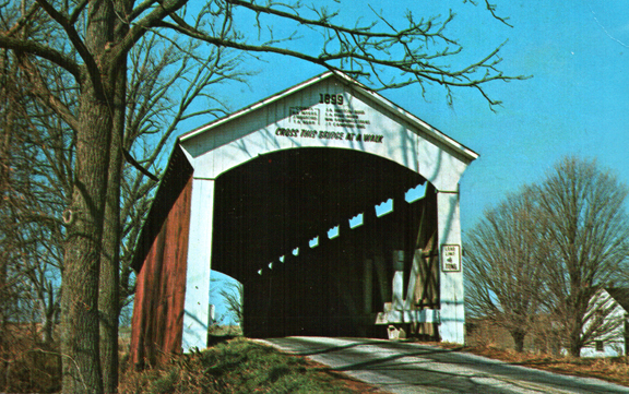
The transplanted Leatherwood Station bridge 14-61-25, from an old post card, before the move.
| 14-61-26 (PC 24) |
East of Montezuma, on CR 20 N in Reserve Twp. À l'est de Montezuma sur CR20 dans le canton Reserve Östlich von Montezuma, auf CR 20 N in Landkreis Reserve |
Leatherwood Creek Ruisseau Leatherwood Leatherwood bach |
Melcher Bridge Pont couvert Melcher Melcher Holzbrücke |
1 miles east of Montezuma on US36 then left on CR 20 N, 1.2 miles to bridge 1 miles à l'est de Montezuma on US36 et `gauche sur CR20N et 1,2 mile vers le pont 1 km östlich von Montezuma auf US36 dann links in die CR 20 N, 1,2 Meilen zum die Brücke |
1 | 83' 25.2m |
Built in 1896 by J. J. Daniels Construit en 1896 par J. J. Daniels Gebaut in 1896 von J. J. Daniels |
Burr/Arch truss Ferme Burr avec arches Burr Träger mit Bogen |
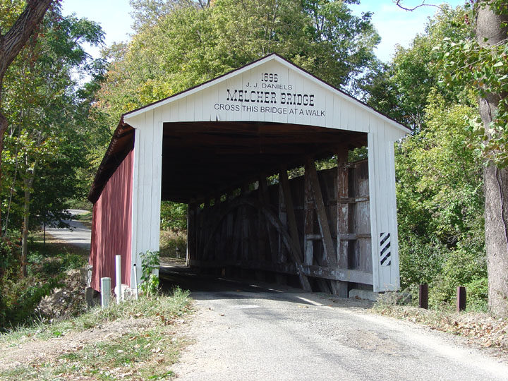
The Melcher bridge near Montezuma 14-61-26, photo Galen Frysinger.
| 14-61-27 (PC 26) |
North of West-Union off CR 525 W in Reserve Twp. Au nord -ouest de West-Union sur la CR525W dans le canton Reserve Nord-westlich von West-Union auf CR525W am Landkreis Reserve |
Sugar Creek Rivières aux sucres Zucker Fluß |
West-Union Bridge, closed to motor traffic Pont couvert de West-Union, fermé au traffic motorisé West-Union Holzbrücke, Fahrzeugverkehr verboten |
About 5 miles west of US41 on CR500N north of Bloomingdale, then 0.5 mile north of West-Union on CR333 to CR525 at the bridge east side of the road Environ 5 mile à l'ouest de la US41 sur la CR500N au nord de Bloomingdale vers West-Union et 0.5 mile vers le nord sur la CR333 jusqu'au pont à la CR525 du côté droit de la route Etwa 5 Mielen westlich von US41 auf CR500N nördlich von Bloomingdale, dann 0,5 Meilen nördlich von West-Union am CR333 zu CR525 an der Brücke Ostseite der Straße |
2 | 315' 96m |
Built in 1876 by J. J. Daniels Construit en 1876 par J. J. Daniels Gebaut in 1876 von J. J. Daniels |
Burr/Arch truss Ferme Burr avec arches Burr Träger mit Bogen |
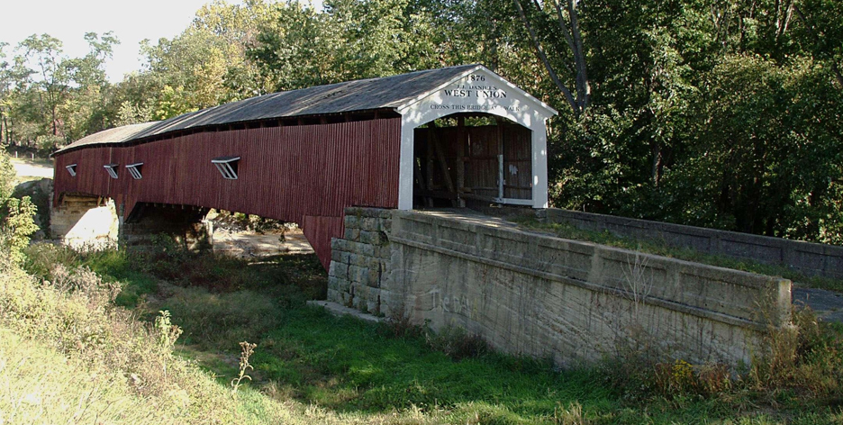
The West-Union covered bridge 14-61-27, photo I Stewart.
| 14-61-28 (PC 28) |
North west of Annapolis on CR50 W in Penn Twp. Au nord-ouest d'Annapolis sur CR50 dans le canton Penn Noord-westlich von Annapolis auf CR50 am Landkreis Penn |
Sugar Creek Rivières aux sucres Zucker Fluß |
Jackson Bridge Pont couvert Jackson Jackson Holzbrücke |
4 miles North-west of US41 through Annapolis on CR625 to CR50 then north to the bridge, one of the longest single span covered bridge in the world! 4 miles au nord-ouest de la US41 par Annapolis sur la CR625 jusqu'à la CR50 vers le nord jusqu'au pont, une des plus grande travée simple au monde! 4 Meilen Nord-westlich von US41 durch Annapolis auf CR625 zu CR50 dann nach Norden bis zur Brücke, eine der längsten einzigen span bedeckte Holzbrücke in der Welt! |
1 | 207' | Built in 1861 by J. J. Daniels, removed, rehabilitated and moved back onto Sugar Creek in 2007 Construit en 1861 par J. J. Daniels, enlevé, reehabilité et replacé sur la rivière en 2007. Gebaut in 1861 von J. J. Daniels, vollständig entfernt, komplett renoviert in 2007, und wieder auf den Fluss |
Double Burr/Arch truss Ferme Burr avec arches doubles Burr Träger mit Doppel Bogen |
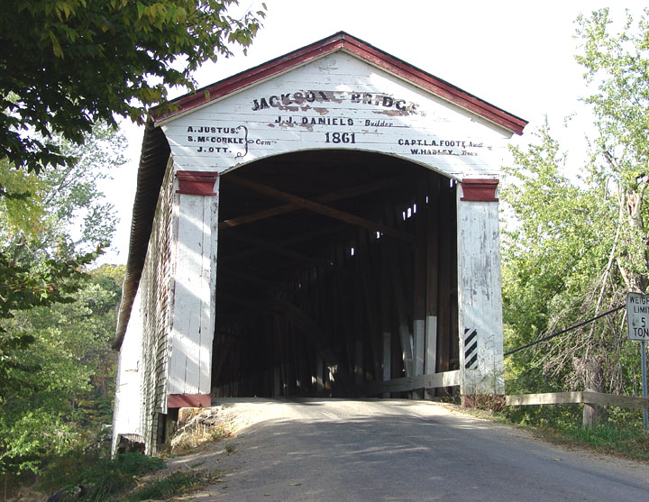
The Jackson Covered Bridge 14-61-28, photos Galen Frysinger.
| 14-61-29
|
South-east of Howard on CR 550 W in Liberty Twp. Au sud-est d'Howard sur CR550W dans le canton Liberté Süd-östlich von Howard am Landkreis Liberty |
Mill Creek Ruisseau du moulin Mühle Bach |
Mill Creek or Tow Path Bridge Pont couvert du Moulin ou du chemin de halage Mühle oder Schleppen-Pfad Holzbrücke |
South-east of Howard on CR 550 W south of CR 1050 N Au sud-est d'Howard sur la CR550W juste au sud de la CR1050N Süd-östen von Howard auf CR550 süden von CR1050N |
1 | 92' 28m |
Built in 1907 by D. M. Brown Construit en 1907 par D. M. Brown Erbaut im Jahr 1907 von D.M. Brown |
Burr/Arch truss Ferme Burr avec arches Burr Träger mit Bogen |

The Tow Path bridge near Howard 14-61-29, photo Galen Frysinger.
| 14-61-31 |
South of Tangier on CR 900 N in Liberty Twp. Au sud de Tangier sur CR900 dans le canton Liberté. Süden vonTangier auf CR900 am Freiheit Lankreis (Liberty Twp.) |
Rush Creek Ruisseau Rapide Schneller Bach |
Rush Creek Bridge Pont couvert de Rush Creek Rush Creek Holzbrücke |
South of Tangier on CR 425 W to CR 900 N left to bridge Au sud de Tangier sur la CR425 jusqu'à la CR900 et à gauche vers le pont Südlich von Tanger auf CR425 dann links auf CR 900 N zum die Brücke |
1 | 77' 23.4m |
Built in 1904 by W. M. Hendricks Construit en 1904 par W. M. Hendricks Gebaut in 1904 von W. M. Hendricks |
Burr/Arch truss Ferme Burr avec arches Burr Träger mit Bogen |
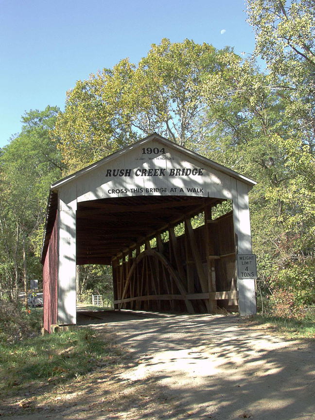
Moon over the Rush Creek bridge 14-61-31, photo by I. Stewart.
| 14-61-32 (PC 29) |
South of Tangier on CR 800 N in Liberty Twp. Au sud de Tangier on CR800 dans le canton Liberté Süden von Tangier auf CR800 am Liberty Landkreis. |
Rush Creek Ruisseau Rapide Schneller Bach |
Marshall Bridge Pont couvert de Marshall Marshall Holzbrücke |
South of Tangier on CR425/450 then left on CR 800 N to bridge Au sud de Tangier sur les CR425/450 et à gauche sur la CR800 vers le pont Südlich von Tangerauf CR425/450 dann links auf CR 800 N nach die Brücke |
1 | 56' 17m |
Built in 1917 by J. A. Britton Construit en 1917 par J. A. Britton Gebaut in 1917 von J. A. Britton |
Burr/Arch truss Ferme Burr avec arches Burr Träger mit Bogen |
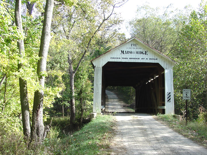
The Marshall bridge near Tangier 14-61-32, photo ATAWALK October 1994.
| 14-61-33 (PC 32) |
North east of Howard on CR 1125 N in Liberty Twp. Au nord de Howard sur CR1125 deans le canton Liberté Norden von Howard auf CR1125 an der Liberty Landkreis |
Mill Creek Ruisseau du moulin Mühle bach |
Bowsher Ford Bridge Pont couvert du gué Bowsher Bowsher Furt Brücke |
7 miles west of US41 past Sylvania and Tangier on CR1050/1025 and north on CR 550 W to CR 1125 N, then left 0.2 mile to the bridge 7 miles à l'ouest de la US41 passer Sylvania et Tangier sur le CR1050.1025 et vers le nord sur la CR550 jusqu'à la CR1125 et à gauche 0.2 mile vers le pont 7 km westlich von US41 Vergangenheit Sylvania und Tanger auf CR1050/1025 dann Norden auf CR 550 W zu CR 1125 N, dann links 0,2 Meilen zum dieBrücke |
1 |
72' 21.9m |
Built in 1915 by Eugene. Britton Construit en 1915 par Eugene Britton Gebaut in 1915 von Eugene Britton |
Burr/Arch truss Ferme Burr avec arches Burr Träger mit Bogen |
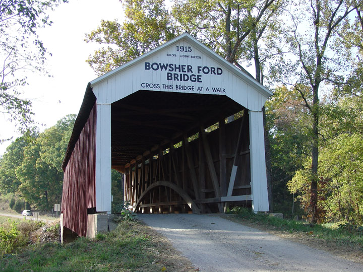
The Bowsher Ford covered bridge 14-61-33, photos Galen Frysinger.
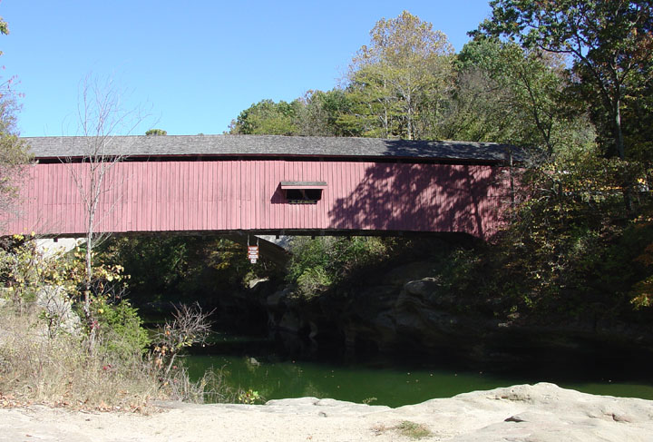
| 14-61-34 (PC 36) |
North west of Marshall on CR100 E, in Penn Twp. Au nord-ouest de Marshall sur CR100 dans le canton Penn Nord-westlich von Marshall auf CR100 E, in Penn Landkreis. |
Sugar Creek Rivières aux sucres Zucker Fluß |
Cox Ford Bridge Pont du gué Cox Cox Furt Holzbrücke |
0.7 mile west of US41 on IN47, then north on CR 100 about 0.8 mile to the bridge 0.7 mile à l'est de la US41 sur la IN47 et à gauche sur la CR100 0.8 mile vers le pont 0,7 Meilen westlich von US41 auf IN47, dann Norden auf CR100 0,8 Meilen zum die Brücke |
1 | 176' 53.6m |
Built in 1913 by J. A. Britton, replaces a steel bridge washed off in 1912 Construit en 1913 par J. A. Britton, remplace un pont de fer emporté en 1912 Gebaut in 1913 von J. A. Britton, es tritt eines Stahl-Brücke zerstört durch die Flut 1912 |
Burr/Arch truss Ferme Burr avec arches Burr Träger mit Bogen |
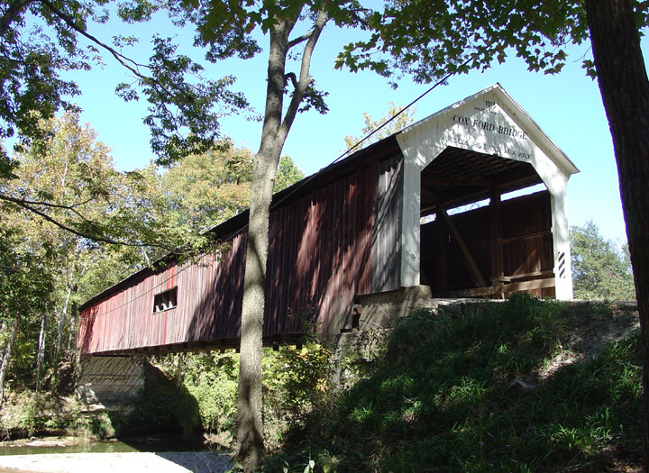
The Cox Ford bridge 14-61-34, photo Galen Frysinger.
| 14-61-35 (PC 35) |
North-west of Marshall off US 41. Au nord-ouest de Marshall en bordure de la US41 Nord-westlich von Marshall auf US41 |
Sugar Mill Creek Rivières du moulin aux sucres Zucker Mühle Fluß |
Wilkins Mill Bridge Pont du moulin Wilkins Wilkins Mühle Brücke |
Just off US 41 0.9 miles north of IN47, right to the creek at CR110 En bordure de la US41 juste 0.9 mile au nord de la IN47 à la rivière sur la CR110 In der Nähe der US41 0,9 Miele nördlich der IN47, Recht auf CR110 an der Fluß und zum die Brücke |
1 | 102' 31m |
Built in 1906 by W. M. Hendricks Construit en 1906 par W. M. Hendricks Gebaut in 1906 von W. M. Hendricks |
Burr/Arch truss Ferme Burr avec arches Burr Träger mit Bogen |
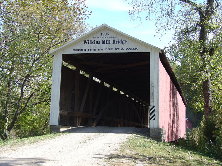
The Wilkins Mill bridge 14-61-35, photo Galen Frysinger.
| 14-61-36 (PC 37) |
At the eastern edge of Turkey Run State Park off CR 300 E in Sugar Creek Twp. À la limite est du parc d'état Turkey Run sur la CR300E dans le canton Sugar Creek Am östlichen Rand der Turkey Run Staat Park auf CR 300 E in Sugar Creek Landkreis. |
Sugar Creek Rivières aux sucres Zucker Fluß |
Narrows Bridge, closed to motor traffic in 1960 Pont couvert du détroit, fermé au traffic en 1960 Narrows Holzbrücke, |
About 9 miles north of Rockville on US41 right on IN 47 and left on CR 300 E, 0.7 mile to the bridge on left side of the road Autour de 9 miles au nord de Rockville sur la US41 et à droite sur IN47 jusqu'à la CR300, à gauche 0.7 mile jusqu'au pont du côté gauche de la route Etwa 9 Mielen nördlich von Rockville auf US41 Recht auf IN 47 und links in die CR300 E, 0,7 Meilen auf der Brücke auf der linken Seite der Straße |
1 | 121' 36.8m |
Built in 1882 by J. A. Britton Construit en 1882 par J. A. Britton Gebaut in 1882 von J. A. Britton |
Burr/Arch truss Ferme Burr avec arches Burr Träger mit Bogen |
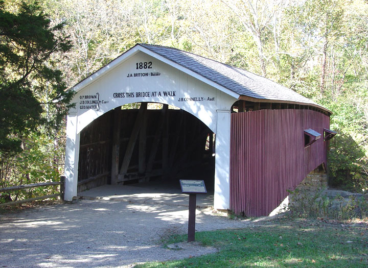
The Narrows covered bridge 14-61-36, photos Galen Frysinger.
| 14-61-38 (PC 01) |
North-east of Rockville past Nyesville off Cr 100N Au nord-est de Rockville passer Nyesville sur la CR 100N Nordöstlich von Rockville zum Nyesville dann Östlich auf CR100N |
Little Raccoon Creek Petite rivière aux Ratons-Laveurs Kleine Waschbären Fluß |
Former State Sanatorium Bridge, replaces Adams and Jessup bridges... Ancient pont couvert du Sanatorium, remplace les pont Adams et Jessup... Staat Sanatorium Holzbrücke, Fahrzeugverkehr verboten |
About 4.5 miles east of Rockville on US36, north on CR 160E to Nyesville in Adams Twp. and right on CR 100N to the bridge Environ 4.5 miles au nord-est de Rockville par la US36 et a gaucge sur la CR 160E vers Nyesville dans le canton Adams, à droite sur la CR 100N jusqu'au pont Ungefahr 4,5 Mielen Nordöstlich von Rockville auf US36 und links auf CR160E zu Nyesville in Adams Lankreis, dam recht.am CR 100N zum die Brücke |
1 | 154' 46.9m |
Built in 1913 by J. A. Britton, moved to the new location in the fall of 2008 Construit en 1913 par J. A. Britton, déménagé au site actuel à l'automne 2008 Gebaut in 1913 von J. A. Brittondie Brücke, Wiederaufbau am neuen Standort, Herbst 2008 |
Burr/Arch truss Ferme Burr avec arches Burr Träger mit Bogen |
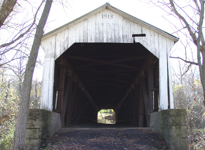
Original location, 1913-2008, the State Sanatorium bridge 14-61-38, photo Galen Frysinger
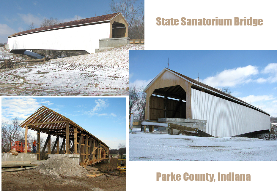
Bret Huggard photos
PORTLAND BOLTS & Manufacturing Co
Third covered bridge at this site since 1907... the State Sanatorium Bridge
was relocated a mile north of its original location in 2008 to the site
of the
Adams Bridge.
The
Original
Adams Bridge was built in 1907 by Jefferson P. Van Fossen and was the same
size as the State Sanatorium Bridge. The Adams Bridge was destroyed by
flood in 1969 and was replaced by the Jessup Bridge in 1970. and was bypassed
in
1988.
The Jessup Bridge was originally built by Jefferson P. Van Fossen and was
located about 1/2 mile north of Jessup. The Jessup Bridge was moved by
Elmer Buchta in 1970 to the Adams Bridge location where it was later destroyed
by flood in 1989.
Lets hope that the State Sanatorium Bridge has better luck at this location
than the original Adams Bridge or the Jessup Bridge did. Info by Treasure
Hunters, fotos ???
Troisième pont à cet endroit, le pont Adams construit en 1907 par Jefferson P Van Fossen fut détruit par une inondation en 1969. On le remplaça par le pont de Jessup construit par Van Fossen également et fut déménagé au canton Adams en 1970 par Elmer Buchta, en 1989, le pont Adams/Jessup fut aussi détruit par un coup d'eau... le pont du Sanatorium est donc le deuxième à être déménager sur ce site, bonne chance!!!
Dritte Brücke an diesem Standort seit 1907 ... der Staat Sanatorium Brücke verlegt wurde eine Meile nördlich von seinem ursprünglichen Standort im Jahr 2008 auf dem Gelände des Adams Bridge. Die Original-Adams-Brücke wurde 1907 gebaut von Jefferson P. Van Fossen und die gleiche Größe wie die staatliche Sanatorium Brücke. Die Adams-Brücke durch Hochwasser zerstört wurde im Jahr 1969 und wurde durch die Jessup-Brücke im Jahr 1970. umgangen und wurde im Jahr 1988. Jessup Die Brücke wurde ursprünglich von Jefferson P. Van Fossen und befand sich etwa 1 / 2 Meile nördlich von Jessup. Jessup Brücke wurde von Elmer Buchta im Jahr 1970 auf die Adams-Brücke, wo sie später durch Hochwasser zerstört im Jahre 1989. Können hoffen, dass der Staat Sanatorium Brücke hat mehr Glück an diesem Standort als das Original Adams-Brücke oder die Brücke Jessup hat.