ponts couverts dans le monde
bedeckte Brücken der Welt
世界各地的棚桥
35-80 UNION
county/comté/grafschaft
8 covered bridges/ponts
couverts/bedeckte holzbrücken
![]()
This symbol indicates this listing has been translated from English to French
and German by ATAWALK
Ce symbole indique que la traduction de cette liste fut effectuer à partir
de l'anglais au Français et à l'Allemand par ATAWALK
Dieses Symbol deutet darauf hin, dass diese Auflistung von ATAWALK vom Englischen
ins Französische und Deutsche übersetzt wurde.
Marysville
| 35-80-01 |
West of Marysville at a wet weather area north of OH245 À l'ouest de Marysville au nord de la OH245 dans un marais Westlich von Marysville, auf eine nasse Wetter Naturpark nördlich von OH245 |
Wetland Marais Sumpf |
First Upper Darby or Pottersburg Bridge, closed to motor traffic Premier pont couvert du Haute Darby ou de Pottersburg, fermé au traffic moteur Ersten Hoch Darby oder Pottersburg Holzbrücke, Fahrzeugverkehr verboten |
6.3 mile west of US33 at Marysville on OH245 to Inkeep Cratty Road, right 1 mile to the bridge on west side of the road 6.3 miles à l'ouest de la US33 à Marysville sur la OH245 jusqu'au chemin Inkeep Cratty et à droite 1 mile jusqu'au pont du côté gauche de la route 6,3 Meile westlich von US33 in Marysville auf OH245 zu Inkeep Cratty Road, rechts 1 Meile auf der Brücke auf der westlichen Seite der Straße |
1 | 94' 28.6m |
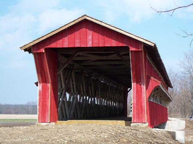
Built in 1868 by Reuben Partridge, moved to present location in July 2006 Construit par Reuben Partridge in 1868, déménagé au site actuel juillet 2006 Gebaut in 1868 von Reuben Partridge, wurde in den Jetzigen Standort im Jahr 2006 |
Partridge truss Ferme Partridge Partridge Träger |
Pottersville or Upper Darby before the move, foto Mark Comstock
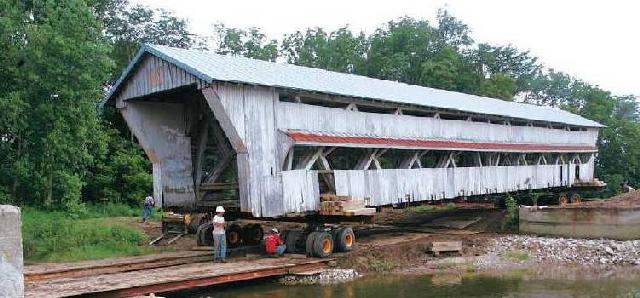
In July 2006, the BIG move to a new location...
SAVED! A superb structure, foto Janis Ford, all the above from the AMAZING DALE TRAVIS WEB PAGE!
H
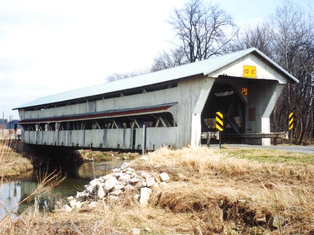
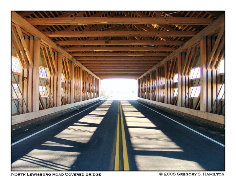
North-Lewisburg
| 35-80-02 |
North-east of North Lewisburg on Cratty Road CR 163 in Allen Twp. Au nord-est de Lewisburg-Nord sur la route Cratty CR163 dans le canton Allen Nord-östlich von Nord-Lewisburg auf Cratty Straße CR163 am Landkreis Allen |
Spain Creek Ruisseau d'Espagne Spanien |
Spain Creek Bridge Pont couvert du ruisseau d'Espagne Spanien Bach Holzbrücke |
1.7 miles east of OH559 at North Lewisburg on OH245, then left 0.1 mile on Cratty Road to the bridge 1.7 miles à l'est de la OH559 à North-Lewisburg sur la OH245, et à gauche 0.1 mile sur la route Cratty vers le pont 1,7 Meilen östlich von OH559 in North Lewisburg auf OH245, dann links auf 0,1 Meile Cratty Straße zum die Brücke |
1 | 64' 19.5m |
Built in 1870 by Reuben Partridge, renovated in 1988-89 Construit en 1870 par Reuben Partridge, révoné en 1988-89 Gebaut in 1870 von Reuben Partridge, renoviert im Jahr 1988-89 |
Partridge truss Ferme Partridge Partridge Träger |
35-80-02 the Spain Creek bridge, photo courtesy Brian J. McKee.
H
Erwin
| 35-80-03 |
North-east of Irwin on Winget Road TR82 in Union Twp. Au nord-est d'Irwin sur le chemin Winget, la TR82 dans le canton Union Nord-östlich von Irwin auf Winget Straße am Landkreis Union |
Treacle Creek Ruisseau à la Mélasse Melasse Bach |
Culbertson, Winget Road or Treacle Creek Bridge Pont couvert Culbertson, Winget ou Treacle Culbertson, Winget oder Treacle Holzbrücke |
2.1 miles east of OH4 on OH161 through Irwin then left 1.2 miles on Homer Road CR 86 and right 0.3 mile on Winget road to the bridge 2.1 miles à l'est de la OH4 sur la OH161 passer Irwin, à gauche 1.2 miles sur le chemin Homer CR86 et à droite 0.3 mile sur la route Winget vers le pont 2,1 Meilen östlich von OH4 auf OH161 durch Irwin dann links 1,2 Meilen auf Homer Weg CR 86 und rechts auf 0,3 Meile Winget Straße bis zur Brücke |
1 | 94' 28.6m |
Built in 1868 by Reuban Partridge. Construit en 1868 par Reuben Partridge Gebaut in 1868 von Reuben Partridge |
Partridge truss Ferme Partridge Partridge Träger |
35-80-03 the Winget Road or Treacle Creek bridge, photos courtesy Mike MacCarter from the WONDEROUS DALE TRAVIS WEBPAGE of covered bridges.
H
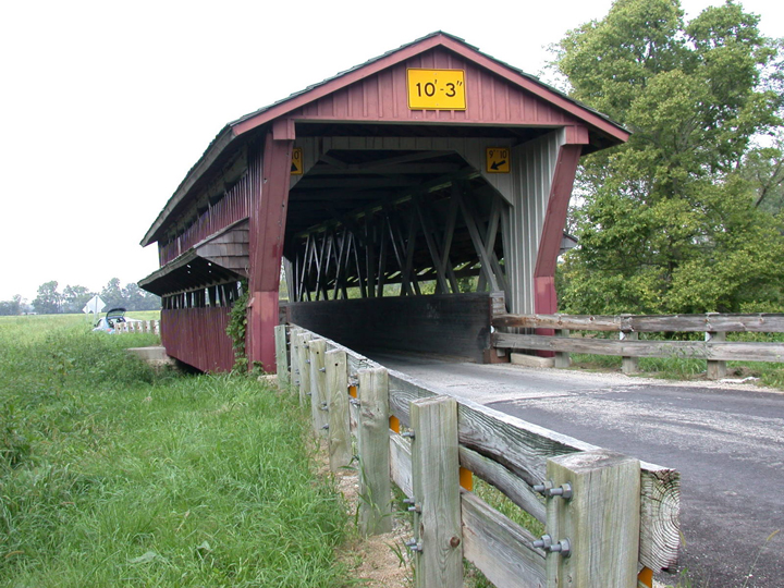
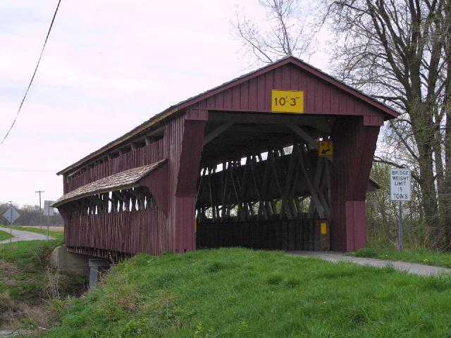
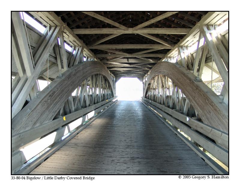
Chuckery
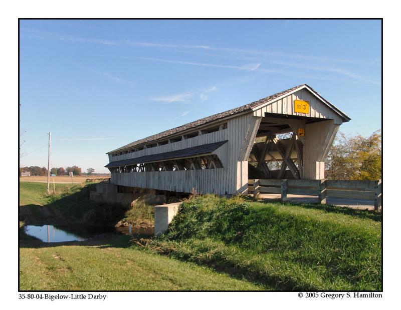
| 35-80-04 |
West of Chuckery on Axe Handle Road CR 87 in Union Twp. À l'ouest de Chuckery sur la chemin du manche de Hache... CR87 dans le canton Union Westlich von Chuckery auf Axtstiel Straße CR87 am Landkreis Union |
Little Darby Creek Petit Ruisseau Darby Kleine Darby Bach |
Axe Handle Road or Bigelow or Little Darby Bridge Pont couvert du Manche de Hache, Bigelow ou de la petite Darby Axstiel, Bigelow oder Kleine Darby Bach Holzbrücke |
About 8 miles west of US42 at Plain City on OH161, right 2 miles west of Chuckery on Axe Handle Road to the bridge Environ 8 miles à l'ouest de la US42 à Plain City, à droite 2 miles passer Chuckery sur le chemin Axe Handle vers le pont Ungefähr 8 Meilen westlich von US42 in Plain City auf OH161, rechts 2 Meilen westlich von Chuckery auf Axe Handle Road zum die Brücke |
1 | 102' 31m |
Built in 1873 by Russel L. Partridge, arches added after original construction, renovated in 1990 Construit par Russel L. Partridge in 1873, arches ajouter plus tard, rénové en 1990 Gebaut in 1873 von Russel L. Partridge, Bögen später hinzugefügt, komplett renoviert im Jahr 1990 |
Partridge truss with arches Ferme Partridge avec arches Partridge Träger mit Bögen |
H
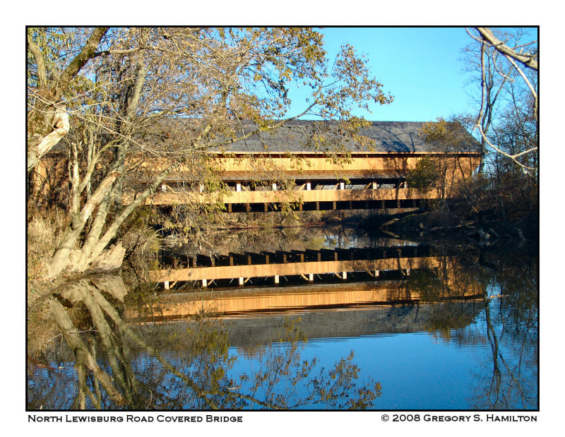
North-Lewisburg
| 35-80-61 |
North-east of North Lewisburg on North Lewisburg Road CR 164 in Allen Twp. Au nord-est de Lewisburg-Nord sur la CR164, le chemin Lewisburg-Nord dans le canton Allen Nord-östlich von North Lewisburg auf der North Lewisburg Straße CR 164 im Landkreis Allen |
Big Darby Creek Grande rivière Darby Große Darby Fluß |
NEW Upper Darby or Pottersburg Bridge #2 Le nouveau pont couvert Haute Darby ou de Pottersburg Das Neue Hoch Darby oder Pottersburg Holzbrücke |
6.3 mile west of US33 at Marysville on OH245 to Inkeep Cratty Road, right 1.6 miles then east 0.1 mile on CR164, North-Lewisburg Road to the bridge 6.3 miles à l'ouest de la US33 à Marysville sur la OH245 jusqu'au chemin Inkeep Cratty et à droite 1.6 mile jusqu'à la CR164, le chemin Lewisburg-Nord, à droite 0.1 mile vers le pont 6,3 Meile westlich von US33 in Marysville auf OH245 zu Inkeep Cratty Road, recht 1,6 Meilen dann östlich 0,1 Meile auf CR164, Nord-Lewisburg Straße zum die Brücke |
1 | 135' 41.1m |
Built in 2006 by the County. Construit par le comté en 2006 Gebaut durch dem Graftschaft im Jahr 2006 |
Pratt truss Ferme Pratt Pratt Träger |
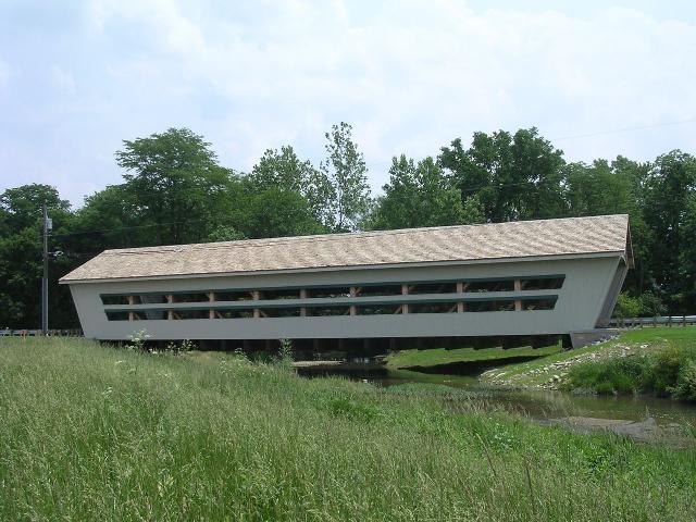
Above and below,
fotos by Brian McKee, from the wonderful DALE TRAVIS WEBSITE
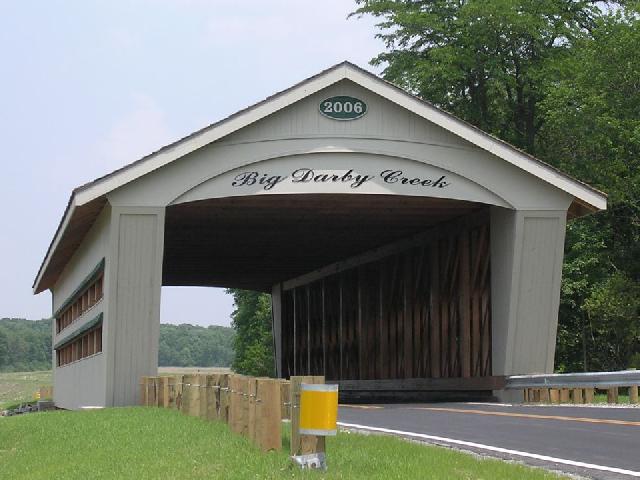
| 35-80-62 |
North-east of North Lewisburg on North Lewisburg Road CR 164 in Allen Twp. Au nord-est de Lewisburg-Nord sur la CR164, le chemin Lewisburg-Nord dans le canton Allen Nord-östlich von North Lewisburg auf der North Lewisburg Straße CR 164 im Landkreis Allen |
Big Darby Creek Grande rivière Darby Große Darby Fluß |
Buck Run Covered Bridge Pont couvert du sentier du cerf Hirsch Weg Holzbrücke |
3 miles west of US33 at Marysville on OH245 and left on Buck Run Road 1.7 miles to the bridge 3 miles à l'ouest de Marysville sur la OH245 et à gauche sur le chemin du sentier du cerf 1.7 miles vers le pont 3 Meilen westlich von US33 in Marysville auf OH245, dann links auf Buck Run Road, Hirsch Weg 1,7 Meilen bis zur Brücke |
1 |
160' 48.7m |
Built in 2006 by the County. Construit par le comté en 2006 Gebaut durch dem Graftschaft im Jahr 2006 |
Pratt truss Ferme Pratt Pratt Träger |
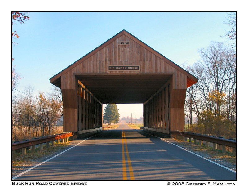
H
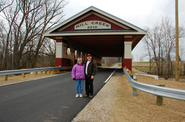
Ostrander
| 35-80-63 |
North of Ostrander south of US36. Au nord d'Ostrander et au sud de la US36 Nordlich von Ostrander und Südlich von US36 |
Mill Creek Rivière du Moulin Mühle Fluß |
Mill Creek Covered Bridge Pont couvert de la rivière du Moulin Mühle Bach Holzbrücke |
0.8 miles southwest of US36 on Ostrander Rd. north of Ostrander, then 2.0 miles south on Stover Rd. (becomes Thompson Rd. & turns east). 0.8 miles au sud de la US36 sur le chemin Ostrander au nord d'Ostrander et 2 miles vers le sud sur le chemin Stover qui devient le chemin Thompson en tournant vers l'est 0,8 Meilen südwestlich von US36 auf Ostrander Rd. nördlich von Ostrander, dann 2,0 Meilen südlich von Stover Rd. (wird Thompson Road. dreht & Ost). |
1 | 138' 48.7m |
Built in 2010 by Zachrich Construction Construit par la firme Zachrich Construction en 2006 Gebaut durch dem Zachrich Bauwerk im Jahr 2006 |
Pratt truss Ferme Pratt Pratt Träger |
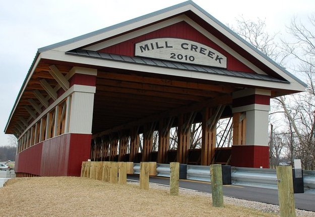
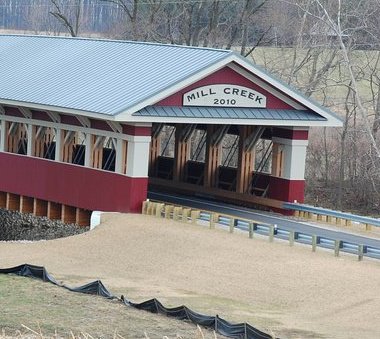
Foto Brian J. McKee
H
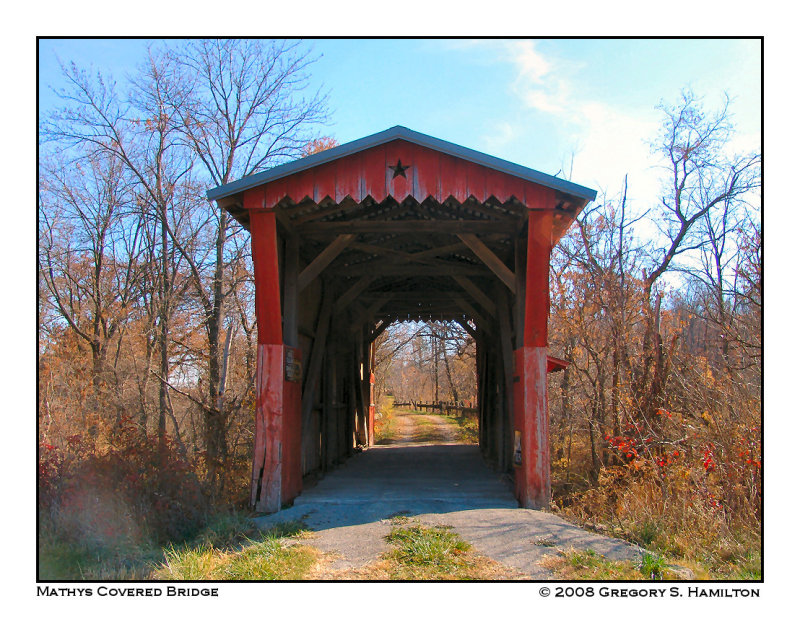
West-Mansfield
| 35-80-A |
East of West-Mansfield off OH47 À l'est de Mansfield-ouest sur la OH47 Östlich von West-Mansfield auf OH47 |
Middle Branch of Bokes Creek Branche centrale du ruisseau Bokes Zentrum Nebenfluß des Bokes Bach |
Mathys Bridge, private Pont couvert Mathys, privé Mathys Holzbrücke, privat |
About 2 miles east of West-Mansfield on OH47, on the east side of the highway on farm access road, ask permission to visit Environ 2 mile à lest de West-MAnsfield sur la OH47 et à droite sur le chemin d'accès de la ferme, obtenir permission de visiter. Ungefähr 2 Meilen östlich von West-Mansfield auf OH47 an der Ostseite auf dem Bauernhof Zufahrtsstraße, um Erlaubnis fragen zu besuchen |
1 | 41' 12.4m |
Built in 1975 Construit en 1975 Gebaut in 1975 |
Queen Post Truss Ferme Queen Zweifaches Hängewerk |