ponts couverts dans le monde
bedeckte Brücken der Welt
世界各地的棚桥

- Home
Acceuil
Startseite
主页 - To The Bridges
Vers les ponts
Zum die Brücken
通往棚桥- America Amerique
美洲 Amerika- USA-United States of America
États-Unis d'Amérique
Vereinigte Staaten von Amerika East/Est/Ost美利坚合众国 - Carolinas North 33 & South 40
Caroline du nord et du sud - Connecticut 07
- Delaware 08
- Georgia Georgie 10
- Maine 19
- Maryland 20
- Massachusetts 21
- New-Hampshire 29
- New-Jersey 30
- New-York 32
- Albany 32-01
- Broome 32-04
- Cattaragus 32-05
- Cayuga 32-06
- Delaware 32-13
- Erie 32-15
- Essex 32-16
- Fulton 32-18
- Genesee 32-19
- Herkimer 32-22
- Jefferson 32-23
- Lewis 32-25
- Madison 32-27
- Oneida 32-33
- Ostego 32-39
- Rensselaer 32-42
- Saratoga 32-46
- Schoharie 32-47
- Schuyler 32-48
- Steuben 32-51
- Suffolk 32-52
- Sullivan 32-53
- Tompkins 32-55
- Ulster 32-56
- Warren 32-57
- Washington 32-58
- Pennsylvania Pennsylvanie 38
- Adams 38-01
- Bedford 38-05
- Berks 38-06
- Bradford 38-08
- Bucks 38-09
- Carbon 38-13
- Chester 38-15
- Clearfield 38-17
- Clinton 38-18
- Columbia 38-19
- Cumberland 38-21
- Dauphin 38-22
- Erie 38-25
- Franklin 38-28
- Greene 38-30
- Huntingdon 38-31
- Indiana 38-32
- Jefferson 38-33
- Juniata 38-34
- Lancaster 38-36
- Lawrence 38-37
- Lehigh 38-39
- Lycoming 38-41
- Mercer 38-43
- Montour 38-47
- Northampton 38-48
- Northumberland 38-49
- Perry 38-50
- Philadelphia 38-51
- Schuylkill 38-54
- Snyder 38-55
- Somerset 38-56
- Sullivan 38-57
- Susquehanna 38-58
- Union 38-60
- Washington 38-63
- Westmoreland 38-65
- York 38-67
- Rhode-Island Île-de-Rhode 39
- Vermont 45
- Virginia Virginie 46
- West-Virginia 48
Virginie Occidentale
- Carolinas North 33 & South 40
- USA-Mid-West / Centre Ouest / Mittelwest
中间西 - Illinois 13
- Indiana 14
- Adams 14-01
- Allen 14-02
- Bartholomew 14-03
- Brown 14-07
- Carroll 14-08
- Clark 14-10
- Dearborn 14-15
- Decatur 14-16
- Dekalb 14-17
- Elkhart 14-20
- Fayette 14-21
- Fountain 14-23
- Franklin 14-24
- Gibson 14-26
- Grant 14-27
- Greene 14-28
- Hamilton 14-29
- Howard 14-34
- Jackson 14-36
- Jennings 14-40
- Kociusko 14-43
- Lake 14-45
- Lawrence 14-47
- Marion 14-49
- Montgomery 14-54
- Owen 14-60
- Parke 14-61
- Perry 14-62
- Putnam 14-67
- Ripley 14-69
- Rush 14-70
- Spencer 14-74
- Vermillion 14-83
- Vigo 14-84
- Wabash 14-85
- Iowa 15
- Kentucky 17
- Michigan 22
- Minnesota 23
- Missouri 25
- Ohio 35
- Adams 35-01
- Ashland 35-03
- Ashtabula 35-04
- Athens 35-05
- Auglaize 35-06
- Belmont 35-07
- Brown 35-08
- Buttler 35-09
- Carroll 35-10
- Clermont 35-13
- Clinton 35-14
- Columbiana 35-15
- Coschocton 35-16
- Cuyahoga 35-18
- Delaware 35-21
- Fairfield 35-23
- Franklin 35-25
- Geauga 35-28
- Greene 35-29
- Guernsey 35-30
- Hamilton 35-31
- Harrison 35-34
- Highland 35-36
- Holmes 35-38
- Jackson 35-40
- Jefferson 35-41
- Knox 35-42
- Lake 35-43
- Lawrence 35-44
- Licking 35-45
- Logan 35-46
- Lucas 35-47
- Mahoning 35-50
- Miami 35-55
- Monroe 35-56
- Montgomery 35-57
- Morgan 35-58
- Muskingum 35-60
- Noble 35-61
- Ottawa 35-62
- Perry 35-64
- Pickaway 35-65
- Preble 35-68
- Ross 35-71
- Sandusky 35-72
- Scioto 35-73
- Summit 35-77
- Trumbull 35-78
- Union 35-80
- Vinton 35-82
- Washington 35-84
- Wayne 35-85
- Williams 35-86
- Wyandot 35-88
- Oklahoma 36
- Tennessee 42
- Wisconsin 49
- USA-Deep South & Far West / Sud & Far-ouest /
Süd und Far-West西和南 - Canada Kanada
加拿大 - British-Columbia 52
- New-Brunswick 55
- Ontario 59
- Quebec 61
- Abitibi-est 61-01
- Abitibi-ouest 61-02
- Arthabaska 61-06
- Beauce sud 61-08
- Berthier 61-11
- Bonaventure 61-14
- Brome-Missisquoi 61-18
- Charlevoix 61-23
- Drummond 61-32
- Dubuc 61-33
- Gaspé 61-37
- Gatineau 61-38
- Huntingdon 61-43
- Johnson 61-50
- Kamouraska-Témiskouata 61-53
- Labelle 61-54
- Laviolette 61-64
- Lotbinière 61-66
- Matane 61-74
- Matapédia 61-75
- Mégantic-Compton 61-76
- Montmagny-L'Islet 61-80
- Nicolet-Yamaska 61-84
- Orford 61-86
- Pontiac 61-90
- René-Levesque 61-93
- Richelieu 61-94
- Richmond 61-95
- Rimouski 61-96
- Roberval 61-99
- Rousseau 61-101
- Rouyn-Noranda-Témiscamingue 61-102
- St-François 61-103
- St-Maurice 61-109
- Westmount-St-Louis 61-125
- Colombia Colombie Kolumbien
- Mexico Méxique Mexiko
- Peru Pérou / Ecuador Équateur
- USA-United States of America
- Asia Asie Asien
亚洲- 不丹王国
Bhutan Bhoutan - 人民共和国的中国 China Chine
- 印度尼西亚
Indonesia Indonésie - 日本
Japan Japon - 马来西亚
Malaysia Malaisie - 新加坡
Singapura Singapore Singapour SG-01 - 斯里兰卡
Sri-Lanka SR-01 - 泰国
Thailand Thaïlande - 越南
Viet Nam
- 不丹王国
- Europe Europa
欧洲- Belgique Belgium Belgien
比利时 - Czech Republik Tchèquie
Tschechische Republik捷克语 - Bohème du Sud / Südböhmen
South-Bohemia CZ-01 - Moravie du Sud / Südmähren
South-Moravia CZ-02 - Bohème centrale / Mittelböhmen
Central-Bohemia CZ-03 - Prague / Prag / Praha CZ-04
- Région de Pardubice/ Die Region Pardubice
Pardubice Region CZ-05 - Les terres-hautes de Vysočina / Die Region Vysočina / Vysočina Highland Region
CZ-06 - Bohème de l'ouest/ Westböhmen
Western-Bohemia CZ-07 - Bohème du Nord / Nordböhmen
North-Bohemia CZ-09
- Bohème du Sud / Südböhmen
- Deutschland Germany Allemagne
德国 - Baden-Württemberg /
Bade Wurtemberg D-01 - Bayern / Bavière / Bavaria D-02
- Berlin D-03
- Brandenburg / Brandebourg
D-04 - Hessen / Hesse D-07
- Niedersachsen / Basse Saxe /
Lower Saxony D-09 - Nordrhein-Westfalen D-10 / Rhineland-Westphalia / Rhénanie du nord Westphalie
- Rheinland-Pfalz D-11 /
Rhineland Palatinat /
Rhénanie Palatinat - Sachsen / Saxonia / Saxe D-13
- Sachsen Anhalt / Saxe Anhalt / Saxonia Anhalt D-14
- Thüringen / Thuringe / Thuringia D-16
- Baden-Württemberg /
- Espana Espagne Spain Spanien
西班牙 - France Frankreich
法国 - Great-Britain Grande-Bretagne Großbritannien
大不列颠 - Italia Italy Italie Italien
意大利 - Norway Norvège Norwegen
挪威 - Österreich Austria
Autriche奥地利 - Russia Russie Russland
俄罗斯 - Suisse Schweiz Switzerland
瑞士 - Sweden Suède Schweden
瑞典
- Belgique Belgium Belgien
- America Amerique
- Subscribe
Abonnement
Abonnement
订阅 - Advertise
Annoncez
Werben
广告 - Contact
Contact
Kontakt
联络方式 - Questions?
Questions?
Fragen?
问题 - Special
Spécial
Besondere
特别 - Internet Links
Liens internet
Verbindungen
连接
14-24
FRANKLIN
county/comté/grafschaft
富兰克林县
4 covered bridges/ponts couverts/bedeckte Holzbrücken/四廊桥
![]()
This symbol indicates this listing has been translated from English to French
and German by ATAWALK
Ce symbole indique que la traduction de cette liste fut effectuer à partir
de l'Anglais au Français et à l'Allemand par ATAWALK
Dieses Symbol deutet darauf hin, dass diese Auflistung von ATAWALK vom Englischen
ins Französische und Deutsche übersetzt wurde
.此符号表示此物品已被翻译从英语到法语,德语和ATAWALK中 .
![]()
WARNING:
The listing below is from the OLD ATAWALK web page
ATTENTION : La liste de cette page provient de l'ancien site ATAWALK
ACHTUNG: Die Auflistung unten ist aus dem Alten ATAWALK Web-Seite
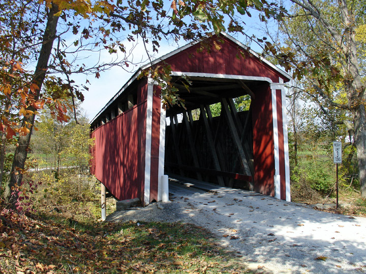
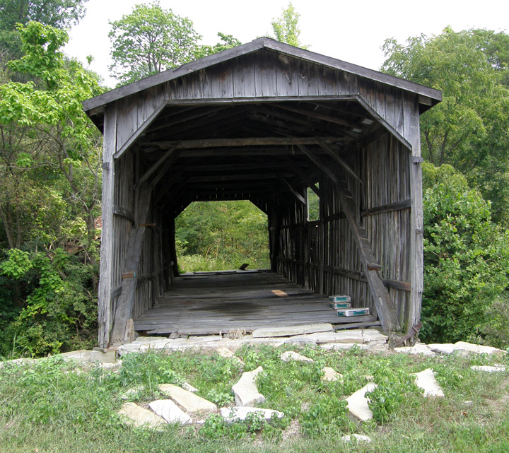
ENOCHSBURG
| 14-24-05 |
East of Enochsburg on Enochsburg Road CR 1480W in Ray Twp. | Salt Creek | Stockheughter or Enochsburg Bridge | 0.3 mile south of jct I-74 at exit 143 to New Point then left 1.7 miles on IN 46, left again on County Line Road CR 1475E 1.8 miles and right on CR 1480W about a mile to the bridge | 1 | 92' | built in 1887 | Howe truss, |
The Stockheughter covered bridge 14-24-05, photo courtesy Galen Frysinger
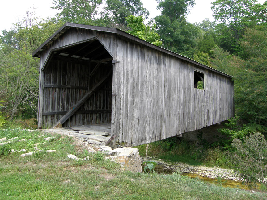
ROCKDALE
| 14-24-09 |
North of Rockdale on Snow Hill Road CR 660S | Johnson Fork of the Whitewater River | Snow Hill Bridge | 1.1 miles west of jct I-74 at exit 169 on US 52 then left 3.7 miles on Jonhson Fork Road CR 800E and just left to the bridge | 1 | 75' | built in 1894 by William Butts and John Horn | Howe truss, |
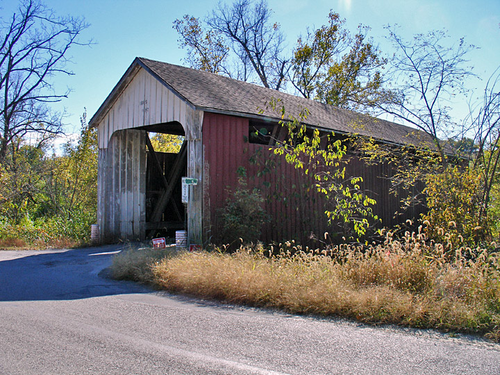
The Snow Hill covered bridge 14-24-09, photo courtesy .
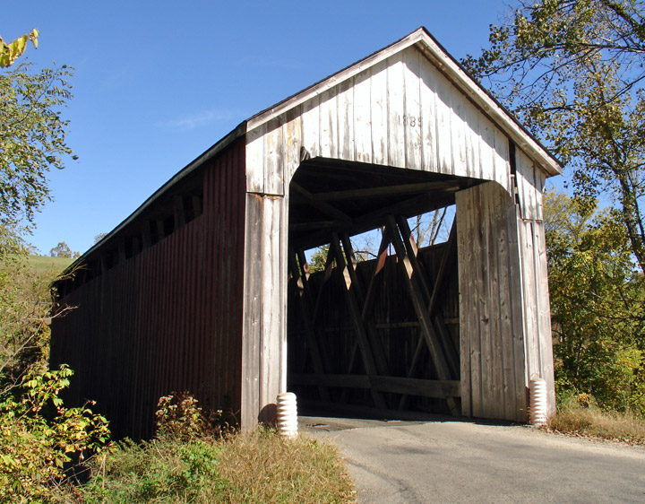
MOUNT-CARMEL
| 14-24-10 |
West of Mount-Carmel on private land off Big Cedar Road in Springfield Twp. | Big Cedar Creek | Seal or Barn Bridge, ask for permission to visit | About 6 miles east of jct IN 1/US 52 on IN 252 past Palestine then right 0.6 mile on Big Cedar Road CR 620E to the bridge on the east side of the road | 1 | 60' | Built in 1905 by George Reuss | Queen truss |
The Seal covered bridge 14-24-10
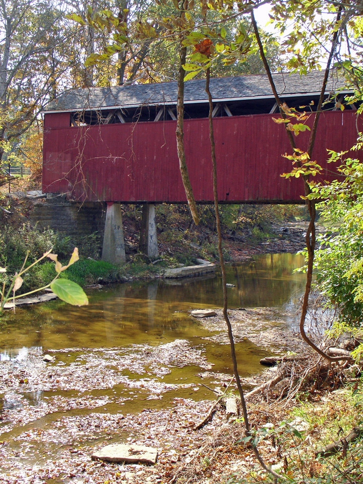
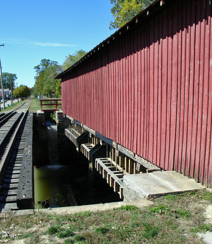
METAMORA
| 14-24-11 |
At the eastern edge of Metamora on the north side of Main Street at Whitewater State Memorial Park in Metamora Twp. À la limite est du village de Metamora du côté nord de la rue Principale au parc d'état mémorial de Whitewater dans le canton Metamora Am östlichen Rand des Dorf Metamora auf der Nordseite der Hauptstraße auf Wildwasser Staatlicher Memorial Park Landkreis Metamora |
Duck Creek Rivière aux Canards Ente Fluß |
Duck Creek Aqueduct or Canal Bridge, open to canal traffic (boats) Aqueduct couvert de la rivière aux Canards ou pont du canal, ouvert aux traffic fluvial Ente Fluß Aquädukt oder Kanal-Brücke, offen für Kanal-Verkehr (Boote) |
About 8 miles north of exit 149 of I-74 at Batesville to Metamora on IN229 than right on US 52 to Columbia/bridge Street and left on Pennington Road, Main Street 0.3 mile to the aqueduct Environ 8 miles au nord de la sortie 149 de l'autoroute I-71 sur la IN229 jusqu'à la US 52 à Metamora, à droite jusqu'à la rue Columbia/du Pont, à droite et à gauche passer le canal sur le chemin Pennington ou rue Principal 0.3 mile jusqu'au pont du côté gauche de la route Ungefahr 8 km nördlich der Ausfahrt 149, I-74 in Batesville zu Metamora über IN229 als Recht auf US 52 bis Columbia / Brücke Straße und links in die Straße Pennington, Main Street 0,3 Meilen zu den Aquädukt auf der Nordseite der Straße |
1 | 81' 24.6m |
Built in 1836-47, completely rebuilt in 1949, restored in 2005 Construit de 1836 à 47, reconstruit en 1949 en complètement restauré en 2005 Gebaut in 1836-47, Wiederaufbau im Jahr 1949, komplett restoriert in 2005 |
Burr Arch with inclined posts Ferme Burr avec arches et poutres inclinées Burr Träger mit bogen und geneigten Stellen |
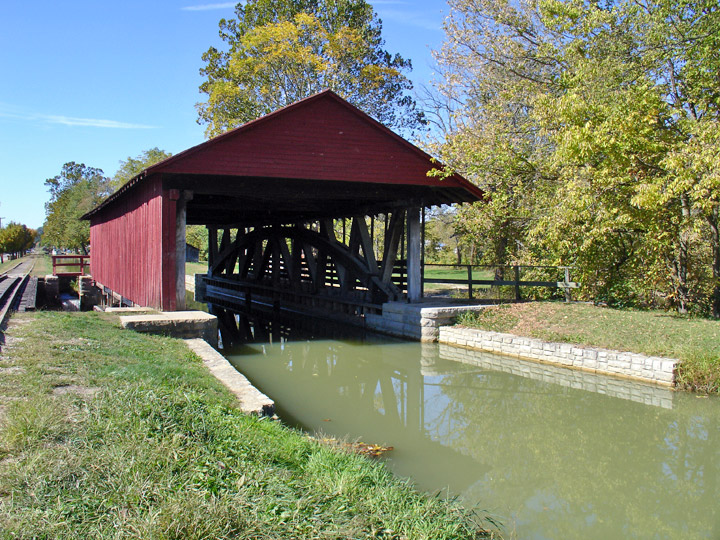
The unique Duck Creek Aquaduct covered bridge 14-24-11 near Metamora, Indiana, photos Galen Frysinger.
MORE INFO about Metamora, CLICK HERE!!!
- Home
Acceuil
Startseite
主页 - To The Bridges
Vers les ponts
Zum die Brücken
通往棚桥- America Amerique
美洲 Amerika- USA-United States of America
États-Unis d'Amérique
Vereinigte Staaten von Amerika East/Est/Ost美利坚合众国 - Carolinas North 33 & South 40
Caroline du nord et du sud - Connecticut 07
- Delaware 08
- Georgia Georgie 10
- Maine 19
- Maryland 20
- Massachusetts 21
- New-Hampshire 29
- New-Jersey 30
- New-York 32
- Albany 32-01
- Broome 32-04
- Cattaragus 32-05
- Cayuga 32-06
- Delaware 32-13
- Erie 32-15
- Essex 32-16
- Fulton 32-18
- Genesee 32-19
- Herkimer 32-22
- Jefferson 32-23
- Lewis 32-25
- Madison 32-27
- Oneida 32-33
- Ostego 32-39
- Rensselaer 32-42
- Saratoga 32-46
- Schoharie 32-47
- Schuyler 32-48
- Steuben 32-51
- Suffolk 32-52
- Sullivan 32-53
- Tompkins 32-55
- Ulster 32-56
- Warren 32-57
- Washington 32-58
- Pennsylvania Pennsylvanie 38
- Adams 38-01
- Bedford 38-05
- Berks 38-06
- Bradford 38-08
- Bucks 38-09
- Carbon 38-13
- Chester 38-15
- Clearfield 38-17
- Clinton 38-18
- Columbia 38-19
- Cumberland 38-21
- Dauphin 38-22
- Erie 38-25
- Franklin 38-28
- Greene 38-30
- Huntingdon 38-31
- Indiana 38-32
- Jefferson 38-33
- Juniata 38-34
- Lancaster 38-36
- Lawrence 38-37
- Lehigh 38-39
- Lycoming 38-41
- Mercer 38-43
- Montour 38-47
- Northampton 38-48
- Northumberland 38-49
- Perry 38-50
- Philadelphia 38-51
- Schuylkill 38-54
- Snyder 38-55
- Somerset 38-56
- Sullivan 38-57
- Susquehanna 38-58
- Union 38-60
- Washington 38-63
- Westmoreland 38-65
- York 38-67
- Rhode-Island Île-de-Rhode 39
- Vermont 45
- Virginia Virginie 46
- West-Virginia 48
Virginie Occidentale
- Carolinas North 33 & South 40
- USA-Mid-West / Centre Ouest / Mittelwest
中间西 - Illinois 13
- Indiana 14
- Adams 14-01
- Allen 14-02
- Bartholomew 14-03
- Brown 14-07
- Carroll 14-08
- Clark 14-10
- Dearborn 14-15
- Decatur 14-16
- Dekalb 14-17
- Elkhart 14-20
- Fayette 14-21
- Fountain 14-23
- Franklin 14-24
- Gibson 14-26
- Grant 14-27
- Greene 14-28
- Hamilton 14-29
- Howard 14-34
- Jackson 14-36
- Jennings 14-40
- Kociusko 14-43
- Lake 14-45
- Lawrence 14-47
- Marion 14-49
- Montgomery 14-54
- Owen 14-60
- Parke 14-61
- Perry 14-62
- Putnam 14-67
- Ripley 14-69
- Rush 14-70
- Spencer 14-74
- Vermillion 14-83
- Vigo 14-84
- Wabash 14-85
- Iowa 15
- Kentucky 17
- Michigan 22
- Minnesota 23
- Missouri 25
- Ohio 35
- Adams 35-01
- Ashland 35-03
- Ashtabula 35-04
- Athens 35-05
- Auglaize 35-06
- Belmont 35-07
- Brown 35-08
- Buttler 35-09
- Carroll 35-10
- Clermont 35-13
- Clinton 35-14
- Columbiana 35-15
- Coschocton 35-16
- Cuyahoga 35-18
- Delaware 35-21
- Fairfield 35-23
- Franklin 35-25
- Geauga 35-28
- Greene 35-29
- Guernsey 35-30
- Hamilton 35-31
- Harrison 35-34
- Highland 35-36
- Holmes 35-38
- Jackson 35-40
- Jefferson 35-41
- Knox 35-42
- Lake 35-43
- Lawrence 35-44
- Licking 35-45
- Logan 35-46
- Lucas 35-47
- Mahoning 35-50
- Miami 35-55
- Monroe 35-56
- Montgomery 35-57
- Morgan 35-58
- Muskingum 35-60
- Noble 35-61
- Ottawa 35-62
- Perry 35-64
- Pickaway 35-65
- Preble 35-68
- Ross 35-71
- Sandusky 35-72
- Scioto 35-73
- Summit 35-77
- Trumbull 35-78
- Union 35-80
- Vinton 35-82
- Washington 35-84
- Wayne 35-85
- Williams 35-86
- Wyandot 35-88
- Oklahoma 36
- Tennessee 42
- Wisconsin 49
- USA-Deep South & Far West / Sud & Far-ouest /
Süd und Far-West西和南 - Canada Kanada
加拿大 - British-Columbia 52
- New-Brunswick 55
- Ontario 59
- Quebec 61
- Abitibi-est 61-01
- Abitibi-ouest 61-02
- Arthabaska 61-06
- Beauce sud 61-08
- Berthier 61-11
- Bonaventure 61-14
- Brome-Missisquoi 61-18
- Charlevoix 61-23
- Drummond 61-32
- Dubuc 61-33
- Gaspé 61-37
- Gatineau 61-38
- Huntingdon 61-43
- Johnson 61-50
- Kamouraska-Témiskouata 61-53
- Labelle 61-54
- Laviolette 61-64
- Lotbinière 61-66
- Matane 61-74
- Matapédia 61-75
- Mégantic-Compton 61-76
- Montmagny-L'Islet 61-80
- Nicolet-Yamaska 61-84
- Orford 61-86
- Pontiac 61-90
- René-Levesque 61-93
- Richelieu 61-94
- Richmond 61-95
- Rimouski 61-96
- Roberval 61-99
- Rousseau 61-101
- Rouyn-Noranda-Témiscamingue 61-102
- St-François 61-103
- St-Maurice 61-109
- Westmount-St-Louis 61-125
- Colombia Colombie Kolumbien
- Mexico Méxique Mexiko
- Peru Pérou / Ecuador Équateur
- USA-United States of America
- Asia Asie Asien
亚洲- 不丹王国
Bhutan Bhoutan - 人民共和国的中国 China Chine
- 印度尼西亚
Indonesia Indonésie - 日本
Japan Japon - 马来西亚
Malaysia Malaisie - 新加坡
Singapura Singapore Singapour SG-01 - 斯里兰卡
Sri-Lanka SR-01 - 泰国
Thailand Thaïlande - 越南
Viet Nam
- 不丹王国
- Europe Europa
欧洲- Belgique Belgium Belgien
比利时 - Czech Republik Tchèquie
Tschechische Republik捷克语 - Bohème du Sud / Südböhmen
South-Bohemia CZ-01 - Moravie du Sud / Südmähren
South-Moravia CZ-02 - Bohème centrale / Mittelböhmen
Central-Bohemia CZ-03 - Prague / Prag / Praha CZ-04
- Région de Pardubice/ Die Region Pardubice
Pardubice Region CZ-05 - Les terres-hautes de Vysočina / Die Region Vysočina / Vysočina Highland Region
CZ-06 - Bohème de l'ouest/ Westböhmen
Western-Bohemia CZ-07 - Bohème du Nord / Nordböhmen
North-Bohemia CZ-09
- Bohème du Sud / Südböhmen
- Deutschland Germany Allemagne
德国 - Baden-Württemberg /
Bade Wurtemberg D-01 - Bayern / Bavière / Bavaria D-02
- Berlin D-03
- Brandenburg / Brandebourg
D-04 - Hessen / Hesse D-07
- Niedersachsen / Basse Saxe /
Lower Saxony D-09 - Nordrhein-Westfalen D-10 / Rhineland-Westphalia / Rhénanie du nord Westphalie
- Rheinland-Pfalz D-11 /
Rhineland Palatinat /
Rhénanie Palatinat - Sachsen / Saxonia / Saxe D-13
- Sachsen Anhalt / Saxe Anhalt / Saxonia Anhalt D-14
- Thüringen / Thuringe / Thuringia D-16
- Baden-Württemberg /
- Espana Espagne Spain Spanien
西班牙 - France Frankreich
法国 - Great-Britain Grande-Bretagne Großbritannien
大不列颠 - Italia Italy Italie Italien
意大利 - Norway Norvège Norwegen
挪威 - Österreich Austria
Autriche奥地利 - Russia Russie Russland
俄罗斯 - Suisse Schweiz Switzerland
瑞士 - Sweden Suède Schweden
瑞典
- Belgique Belgium Belgien
- America Amerique
- Subscribe
Abonnement
Abonnement
订阅 - Advertise
Annoncez
Werben
广告 - Contact
Contact
Kontakt
联络方式 - Questions?
Questions?
Fragen?
问题 - Special
Spécial
Besondere
特别 - Internet Links
Liens internet
Verbindungen
连接